Including...
Introduction
Background Information
The Regional Geologic and Tectonic Setting
The Rocks
Sediments
Extrusive basalt
Sheeted dikes
Gabbro
Ultramafics
The Tours
The Smith River section
The Galice section
Closing Comments
Introduction
For all of the complexity we see on the surface, it's really pretty simple: heavy stuff sinks and light stuff floats. If an alien landed on earth and said something like "Hey dude, nice planet. What's happenin'?" I would have to answer with "It's sorting itself by density, of course." Since any society sufficiently advanced to have space travel would also have the sense to send a geologist on the trip, he (or she or it) would understand, and probably respond with something like "Yeah, mine too." Then we'd grab a 6-pack of our favorite beverage, find a sunny spot along a river, and enjoy the day. Geologists do that (there have to be some absolutes in the universe).
If we stand way back and look, fundamentally the earth has two elevations: below and above sea level. And, as fortune would have it, there are really only two types of rock at the surface: basalt and granite. And best of all, these two elevations and two types of rock relate to each other due to the density separation process. Basalt is dense and heavy, and forms the crust beneath the oceans. Granite, being lighter in both color and density, accumulates as thick, continent-sized rafts which float about in this sea of basalt. It's important to note that the oceans are where they are because of the density differences between these two rocks. The heavier basalt forms the low spots which then act as the container for our earth's primary fluid reservoir - the ocean.
Basaltic magma is like the blood of the earth: it's what comes out when the earth's crust is cut the whole way through. Once the magma comes to the surface and cools into basalt rock, it gets moved around and beaten up by all kinds of forces. It can even be pushed back down into the earth and re-melted, allowing the elements in the rock to continue separating by density. The heavy stuff (iron, magnesium, etc.) has another opportunity to sink deeper into the earth, and the lighter elements (silica and oxygen, aluminum, potassium) become concentrated at the surface (kind of like scum). Granite is the final result, and in the 4.6 billion years of earth history our planet has managed to purify and accumulate enough granitic rock to cover approximately 25% of its surface.
When you consider how much oceanic crust has been formed over the course of geologic time, it's pretty amazing how little of it is exposed above sea level. If a chunk of this deep-sea crust does manage to beat the odds, and get mixed in with the granite and other rocks which make up the continental land masses, we call it an ophiolite. This GeoTour will take you on a trip through the Josephine Ophiolite: one of the most complete and best exposed ophiolites on earth.
Background Information
It will REALLY help if you have some limited background on the earth, its processes, and its rocks. If you are unfamiliar with any of the general terms or concepts used on this tour, feel free to jump to the indicated links as needed. If you are a complete novice, you may want to look at some of this information before continuing.
Click here to go to the background section
Click here to go to the AskGeoMan Index
No matter what your level of expertise in the earth sciences, you may wish to review some basic ideas on how the earth works (or at least my version of them). Click here to go to a general tectonic overview.
The regional geologic and tectonic setting
Lots of folks have been studying the rocks of southwestern Oregon and northwestern California in recent years, and extensive lists are available from many sources. Pioneer workers including Diller (1914), Winchell (1914), and Shenon (1933), mapped the many mines and prospects which were being actively worked in the region in the early 1900's, and the miners of the late 1800's knew enough about the local geology to find most of the exposed gold and other valuable minerals. Certainly the native American tribes used the bounty of the physical earth in all aspects of their lives. No doubt about it, the rocks are here for those who want to look.
From a regional point of view, an ophiolite is just a chunk of the seafloor that got shoved up above sea level. As discussed in the background section, the basalt which forms the seafloor is made at spreading centers and moves away until it runs into something (usually a continent). At that point, because of differences in density, it slides below the continent and is consumed in a subduction zone. It takes a pretty amazing set of circumstances for a piece of this stuff to survive the subduction process and wind up where we can see it without getting wet. Fortunately, since the earth has plenty of time, sooner or later it's bound to happen. And it has, again and again throughout geologic history. In most cases, the "amazing circumstances" involve lots of pushing, squeezing, and faulting. These tectonic processes generally result in an ophiolite which is pretty broken up, and it is common to find that many of the pieces are missing. One of the beauties of the Josephine Ophiolite is that it survived the tectonic processes relatively intact, and all of the major sections can be found (if one knows where to look).
The Josephine Ophiolite occurs in the Klamath Mountains Geomorphic Province of northwestern California and southwestern Oregon. Again taking a regional view, the Klamaths are "an accumulation of four arcuate, north-south trending, litho-tectonic belts" which were formed by "the repeated accretion, beginning in the early to middle Paleozoic and continuing through the Mesozoic, of ophiolitic and/or island arc terrains, and their associated sedimentary units, to the western edge of the North American continent." Welcome to GeoSpeak (courtesy of my 1986 report on the Turner-Albright Massive Sulfide Deposit). Translation: Subduction has been taking place along the west coast of North America for the past several hundred million years. Imagine several bananas smooshed together with the ends pointing to the east. If you view the bananas as the remains of older subduction complexes, and the volcanic arcs which formed above them, you've got the basic idea. Throw in the odd chunk of seafloor, and a bit of newly purified granitic continental crust, and all of the pieces are accounted for. Since this regional "zone of convergence" lasted for such a long time, the remains of several of these "subduction zone/volcanic arc/ophiolite/granitic" complexes have been jammed up against (accreted to) the leading edge of the North American plate.
Even the ages of the rocks make sense. The banana on the inside, and closest to the bulk of North America, was the first to form and so it's the oldest of the preserved subduction complexes (kind of a weird twist to the concept of Superposition). This first subduction/arc complex collapsed, was shoved up against the edge of the continent, and a new subduction zone developed to the west. And so on for 350 million years or so. The western-most "litho-tectonic belt," on the outside of the arc, is the youngest of the preserved Klamath Mountain subduction complexes. This one's called the Western Jurassic Belt, and since it's where the 157 million year old Josephine Ophiolite lives, we'll spend some time here. (Please note that subduction is still occurring off the coast of Washington, Oregon, and northern California, with a trench offshore and a volcanic arc we call the Cascade Range forming on land.)
 Step way back. Which plates were (and still
are) in collision? The North American plate was (and still is)
moving to the west away from the Mid-Atlantic Ridge. It was (and
still is) interacting with the floor of the Pacific Ocean, which
was (and still is) moving to the east. Actually, both North and
South America are moving to the west, where they are in contact
with the Pacific plate from Alaska to the tip of South America.
This has been going on for several hundred million years, and
has resulted in the subduction of many potential ophiolites,
as well as the formation of immense amounts of continental (granitic)
rock. What happens to this newly purified rock? It gets welded
to the edge of the craton,
and the raft of granite we call North America gets a little bit
bigger. And it's still growing! (Note: geologically "recent"
events have complicated this simple regional model for western
North America. Click here
for additional information on this complex tectonic setting.)
Step way back. Which plates were (and still
are) in collision? The North American plate was (and still is)
moving to the west away from the Mid-Atlantic Ridge. It was (and
still is) interacting with the floor of the Pacific Ocean, which
was (and still is) moving to the east. Actually, both North and
South America are moving to the west, where they are in contact
with the Pacific plate from Alaska to the tip of South America.
This has been going on for several hundred million years, and
has resulted in the subduction of many potential ophiolites,
as well as the formation of immense amounts of continental (granitic)
rock. What happens to this newly purified rock? It gets welded
to the edge of the craton,
and the raft of granite we call North America gets a little bit
bigger. And it's still growing! (Note: geologically "recent"
events have complicated this simple regional model for western
North America. Click here
for additional information on this complex tectonic setting.)
But we digress...
One of the ways that a chunk of seafloor
can end up high and dry is if spreading takes place behind the
subduction zone, between the volca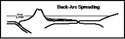 nic
arc and the mainland. Weird stresses can occur around subduction
complexes, and these "back-arc spreading centers" actually
do form. When they do, and if the volcanic arc gets shoved into
the continent, the chunk of seafloor can get stuck in between.
This is what is thought to have happened in the case of the Josephine
Ophiolite. We'll visit many examples from both the seafloor crust
(the Smith River section) and the collapsed
volcanic arc (the Galice section) before
the end of this tour.
nic
arc and the mainland. Weird stresses can occur around subduction
complexes, and these "back-arc spreading centers" actually
do form. When they do, and if the volcanic arc gets shoved into
the continent, the chunk of seafloor can get stuck in between.
This is what is thought to have happened in the case of the Josephine
Ophiolite. We'll visit many examples from both the seafloor crust
(the Smith River section) and the collapsed
volcanic arc (the Galice section) before
the end of this tour.
The Josephine ophiolite/volcanic arc complex has surely been pushed around in the 157 million years since it was active. The extensive faulting which collapsed the arc and shoved the whole mess into the edge of the continent also broke it into many separate pieces, making it tough to get a clear picture of what is (and therefore "what was"). Regionally, it seems as though the entire ophiolite has been raised up on the west and is now dipping steeply to the east. Unfortunately, the local variations are endless (and provide countless examples of how Strickler's 1st Law of GeoFantasy can keep you from going crazy). And there are other reasons why it's difficult to decipher a clear regional model. The exposure is incomplete: too many trees, and parking lots, and dirt, and brush, and more brush, and more brush. And nature seems to have a wicked sense of humor - between the rattlesnakes, yellowjackets, and old-growth poison oak a poor boy can get worked to death. Also, much of it is either gone due to erosion, or is still buried and waiting to be exposed (so it can be lost to erosion). But your ever faithful GeoMan continues to labor far afield in search of additional information on the Josephine Ophiolite (all the while humming "The Volga Boatman" and listening to the whips crack).
The Rocks 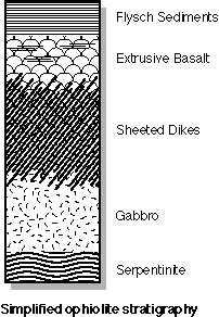
Most ophiolites have a common layered sequence of rock types (called a stratigraphy). In general, classical ophiolite stratigraphy includes five distinct layers. The middle three layers (extrusive basalt, sheeted dikes, and gabbro) make up the actual seafloor crust and are the result of igneous and tectonic processes at spreading centers. The uppermost layer (a.k.a. the flysch sediments) is composed of sedimentary debris which has been washed down rivers to the ocean and settled out of the water to pile up onto the seafloor. The lowest layer (serpentinite) is actually part of the upper mantle, and represents material which occurs beneath oceanic crust and is left behind after the differentiation process makes basaltic magma. Take this opportunity to familiarize yourself with the diagram of ophiolite stratigraphy found to the right. We will be referring to it many times. Please note that this is a greatly simplified diagram, and it is certain that some geologists would include additional layers within layers, subdivisions of layers, or use different names. Most should agree, however, that the five discussed here will be present in all true ophiolites. It is important to remember that we're taking a very broad, regional look. The local details are endless, and while they definitely add spice to the story, at our level of study they would probably only bring needless complexity to an already confusing topic!
The stuff on top: the Jurassic Galice Sediments (Jgs)
We've agreed that ophiolites are chunks of the seafloor. Therefore, we can expect to see lots of mafic magma which has cooled into basalt, diabase, or gabbro (we won't be disappointed). But after the magma erupts, cools and crystallizes, and moves away from the rift, it lies exposed on the seafloor. All sorts of loose stuff piles on top of it during its journey to the subduction zone. Most of this is rock debris washed down from the continents (called "terrigenous sediments"), but some of it is other stuff: shells, bones, teeth, and other evidence of life. And now humans, who are dumping the most amazing things on the seafloor. Think about it: soda pop cans, dead ships, nuclear waste, and cigarette butts by the trillions of trillions.
Anyway, nothing so exciting here. Most of the Jurassic Galice Sediments (Jgs) are shallow to deep water accumulations of rock fragments (called "clasts") which were washed in from the land by rivers and streams. These clastic terrigenous sediments pile up and, over the course of geologic time, are compacted and cemented into rock by a process called lithification. We're going to call the two main types of sedimentary rock associated with the Josephine Ophiolite "shale" and "graywacke."
There are two main factors which are important when naming sedimentary rocks: the size of the clasts, and what they are made of. All different sizes and types of material are washed into the ocean (refer to Strickler's 3rd Law of GeoFantasy). Where they settle out and fall to the seafloor depends upon their size, and the amount of energy in the water. In most cases, fast moving water has more energy, and can keep larger clasts in motion. Therefore, we should expect that the higher wave energy at the beach will keep all the silt and clay suspended in the water, and only the bigger pieces will be heavy enough to settle to the seafloor. And sure enough, that is what we find - sand (and even some gravel if the energy is great enough). Where is the silt and clay? It accumulates farther offshore, where the wave energy is gone and the small stuff can start to settle. How about the big pieces: pebbles, cobbles, and boulders? They're still upstream, waiting for additional weathering to break them down into smaller clasts which the rivers can pick up and move.
What the sediments are made of is clearly related to the types of rocks which are found upstream. But it also has a lot to do with the lengths of the rivers which are transporting the sediments to the ocean. Long river systems (usually associated with passive continental margins) allow lots of time for the weathering processes to completely break down the rock fragments, and what you usually end up with is clean quartz sand for the beach, and clay which settles to make shale in the deeper water (the continents make lots of quartz, and since quartz is relatively inert and resistant to chemical attack, it tends to survive as distinct sand-sized grains). In the short river systems common to active continental margins, the chemical weathering isn't complete, and so the resulting clastic debris is "dirty," with lots of partially weathered minerals and rock fragments mixed in with the quartz and the clay. We call the "dirty sandstone" graywacke, and the dirty shale either shale, mudstone, or siltstone. Because of the textural and compositional variations found in sedimentary rocks, geologists can often get an idea about what kind of depositional environment was present, as well as how long the rivers were and what types of rocks were upstream.
This is the situation we find with the Galice Sediments. Not only were the rivers draining the western slope of North America fairly short (as they still are), but they were (and still are) eroding large amounts of intermediate to mafic rock and debris. The resulting mix of sediments was (and still is) relatively dark and dirty, with only small, local areas of clean quartz sandstone. We'll see lots of graywacke on our tour.
The Galice Formation is in "depositional contact" with the underlying basaltic portion of the ophiolite. What this means is that deposition of the sediments occurred directly on top of the basalt flows, as opposed to a contact which was faulted or in some other way pushed together. An excellent example of this "conformable" contact can be seen along the Smith River just above the mouth of Patrick's Creek.
Seafloor crust: the Jurassic Rogue Volcanics (Jrv)
In the Western Jurassic Belt of the Klamath Mountains, extrusive igneous rocks (both ophiolite and arc derived) have been lumped together and named the Rogue Volcanics. Regionally they include the full range of volcanic materials: mafic to locally felsic flows and associated pyroclastics (tuffs, breccias, and agglomerates). Ophiolitic members related to the spreading center (see the Smith River tour) include basaltic flows and pillows, with inter-layered breccias, hyaloclastites, and relatively thin clastic and/or chemical sedimentary horizons. Pyroclastics and flows associated with volcanic arc development (see the Galice tour) are also relatively mafic (for the most part), but include local horizons of intermediate to felsic material which piled up on top of the mafic seafloor basalt as subduction continued (see the Almeda Mine stop for a good example). Regionally, the whole section is probably an excellent example of an oceanic to oceanic subduction zone, with some behind-the-arc spreading thrown in to keep things interesting. If we go further west (we won't), we actually run into a thick pile of dirty sediments which are thought to have accumulated in the subduction trench seaward of the volcanic arc. Tune in later for another GeoTour along the Rogue River Trail, which will spend time in these sedimentary rocks and identify the major thrust fault which separates them from the rocks of the Rogue Volcanics.
Basalt is great stuff, and there sure is a lot of it on our tour. As mentioned elsewhere, basalt is an extrusive igneous rock. What this means is that it was originally in the liquid phase, the magma somehow got pushed up and out of the magma chamber, it cooled at the surface... and formed basalt. Extrusive magma is called lava, and we generally find it associated with things we call volcanoes. In the case of basalt, the volcanoes often occur in areas of active rifting where the earth's crust is cut the whole way through and magma differentiated from the upper mantle is allowed to escape. For a variety of reasons (mostly related to density), these spreading ridges usually occur on the seafloor where we can't see them. In fact, it wasn't until recently that we developed submersibles which could dive to the deep ocean floor and allow geologists the opportunity to observe crustal spreading directly. Throughout geologic time, crustal spreading has been one of the most constant and active of our planet's tectonic processes, and an immense amount of basalt has been formed (and will continue to be formed well into the distant geologic future). The important thing to remember is that these are the processes which create the basalt which creates the seafloor.
Many geologists call this volcanic layer of ophiolite stratigraphy the "pillow basalt" layer. This refers to the spherical shapes which are commonly formed as basaltic magma is squeezed onto the seafloor. A thin crust cools as the lava erupts into the water, more lava is pushed out behind, and it kind of blows up like a balloon. This cooled crust is often glassy and brittle, and tends to break off, forming angular fragments which fill in around the bulk of countless individual pillows. These broken fragments are called by one of several different names depending on local conditions (which we won't worry about at this stage of the discussion). Names can include epiclastic breccia, hyaloclastite breccia, or the more general term "inter-pillow breccia," which, in the interest of simplicity, will be used on our tour.
While basalt pillows can be found in many locations, I prefer the term "extrusive basalt" for this layer of the ophiolite because I have seen far more non-pillow forms than pillow forms. You will, too, on the tour. As a matter of fact, you may not see any pillows at all (sorry - no refunds). Two of the tour's best pillow locations are at the Turner-Albright massive sulfide deposit, and at the Rogue/Galice contact along the Smith River. Unfortunately, both are often inaccessible due to gates, high water, and other inconveniences. Fortunately, there is a heck of a lot of basalt in the Pacific Northwest, and there are other locations where we can see some GREAT pillows. Probably the best and easiest to get to is along Interstate-5 immediately south of Roseburg, Oregon. Take I-5 southbound from the city center (Exit 124) to McLain Road (Exit 121). You are in basalt the entire way (with some amazing flows at the city center onramp). Pull onto the wide shoulder and park at the beginning of the McLain offramp. Be sure to get your vehicle far enough off the roadway so that you don't get hit (there's plenty of room). The roadcut at the McLain exit contains very well developed pillows. Another excellent exposure is on Oregon Highway 42 at the base of the thick sedimentary sequence exposed along the Middle Fork of the Coquille River (tune in later for another GeoTour).
Many times the rip in the crust is very active and huge amounts of basaltic lava flow out onto the seafloor. When these times of extremely active spreading occur, the greater volume of magma apparently doesn't form pillows, but piles up as thick flows which cool slowly in their centers. This leads to a coarsening of the grain size and the possible confusion with intrusive gabbro (like happened at the Turner-Albright in the mid-1970's). It seems to me that the general lack of pillow forms in many parts of the Josephine Ophiolite indicates a relatively rapid rate of spreading, but there may be other reasons for the general lack of pillow development in the tour area.
There are also times the rip in the crust is relatively inactive, and very little basaltic magma is generated for a long span of geologic time. But that doesn't mean that nothing is happening. Lots of other stuff can be vented onto the seafloor along with the basaltic magma. Spreading ridges are extremely active tectonic environments, and in general have a very high heat flow because of the magma so near to the surface. They are also under the water, and are extremely broken up by countless fractures and faults. If you put all of this together, you wind up with an environment in which descending sea water is allowed to come in contact with some very hot rocks. Water can dissolve anything (see Strickler's 4th Law of GeoFantasy). As the seawater heats up, it becomes even more chemically active than normal, and begins to react with the mafic rock of the seafloor. These reactions take many forms, and the reality of the chemistry is well beyond the scope of this discussion. However, it is certain that the hot water dissolves, or "leaches," elements directly from the rock. Different minerals and elements react with the water at different rates. Some of the easiest to leach include iron, sulfur, silica, copper, zinc, and several other elements which are present in the basalt in relatively small amounts. As these mineral-rich waters increase in heat they become lower in density and begin to rise (through a process called convection). Eventually they reach the seafloor, where they are vented in hot water plumes we call hydrothermal vents. These hot water vents come in two flavors: white smokers and black smokers.
White smokers are hot water vents which contain mostly silica. When the water cools, the silica combines with oxygen and forms layers of siliceous ooze which can pile up on the seafloor and produce sedimentary layers of nearly pure quartz (which lithify into a sedimentary rock which we'll call chert). Another way to get layers of silica ooze is as follows: all this excess silica in the seawater stimulates the growth of one-celled organisms which use silica to build their shells. When these microscopic critters reproduce or die (and they do so by countless bazillions), their shells sink to the bottom where they pile up as layers of silica ooze. Along with these "pelagic sediments," there are small amounts of terrigenous sediments in the water which are settling to the bottom all over the place. Putting this altogether, it is not uncommon to find relatively thin layers of very silica-rich sediment mixed in with the basalt. We will see these at several locations (the manganiferous mudstones south of Baker Flat, and in the Galice area west of the Almeda). As an additional note: analysis of these siliceous muds is one way for geologists to come up with an age for the Josephine Ophiolite. The radiolarians which supplied the shells to pile up as the ooze evolved rapidly, and that allows geologists with real good microscopes (as well as lots of patience) to arrive at a relative age for their shells (and, therefore, the ophiolite as a whole).
Black smokers are similar to white smokers, but they also contain sulfur and metals along with the silica. As mentioned above, basalt contains relatively small amounts of these metals, but... there is an enormous volume of seafloor basalt with which the percolating waters can react. When the ascending waters cool, the sulfur combines with the metals to form sulfide minerals (chalcopyrite, sphalerite, galena, and others). These pile up on the seafloor, and, if uplifted to the surface, can become important sources of many valuable minerals. The Turner-Albright copper/gold/zinc deposit is an excellent example of these "volcanogenic massive sulfide" mineral deposits.
The plumbing system: Sheeted dikes
I realize that the sheeted dikes should be next (at least stratigraphically), but they will make a lot more sense if we talk about the gabbro first and come back to the sheeted dikes later. Click here if this is a problem and you just have to hear about them now.
The magma chamber: Gabbro
The lava that cools to form basalt has to come from somewhere. It's a pretty good bet that it doesn't fall from the sky, and its been several hundred years since anyone has proposed that igneous magma precipitates directly from seawater. Unfortunately, this tends to narrow our search, and forces us to focus on the one place we can't ever get to... deep in the earth where the temperature is high enough to allow rock to exist in the liquid state. Because of the inaccessibility of the location, any discussion of the origins of basaltic lava is necessarily vague, and relies for the most part on inference and conjecture. We've never been there, we'll never get there, and we'll never really know for sure if our ideas are correct. Such is the blessing and curse of any study of igneous and tectonic processes.
As discussed above, the extrusive volcanic rocks which make up the seafloor result from the cooling of lava - liquid rock which crystallizes rapidly when it is exposed at the surface of the earth. But not all lava makes it to the surface. In fact, if it doesn't reach the surface we don't even call it lava. The general term for any rock in the liquid (molten) state is "magma." It is believed that magma originates below the surface, and resides in vaguely defined areas called "magma chambers." An extremely nebulous term, indeed! Do magma chambers have tops, bottoms, sides? Are there flashing red lights at the doors? Sounds stupid, but we'll never know. Fortunately, we can surmise several features from looking at the intrusive igneous rocks which probably represent cooled portions of magma chambers. We're still pretty fuzzy on the side and bottom issue (especially the bottom), and there is no concrete evidence for warning lights, but the tops can be observed in many places. These often indicate an intricate transition from the intrusive body itself into the "country rock" which was there originally. In many locations near to the margins of large intrusive masses, pieces of the country rock are actually found within the igneous rock, indicating that portions of the "roof" fell into the magma as it was cooling (we call these pieces inclusions, or xenoliths). In many cases, the country rock has been subjected to so much heat that it is greatly changed, and some of the highest grade metamorphic rocks are associated with the margins of large intrusive bodies. It also seems certain that in some cases felsic magmas are derived from the intense heating and complete re-melting of existing rocks (the ultimate recycling process). It also seems logical that magmas can only form where the pressure has been released to the point that the hot, plastic material can expand enough to transform into the liquid phase. These relatively low pressure areas would seem most likely to occur in areas of active crustal breakage, such as spreading ridges and subduction zones. In any event, the study of intrusive igneous rocks can take a lifetime, and so we'll leave the rest of this discussion for now.
Identification of igneous rocks is based on 2 things: composition of the magma (felsic, mafic, and all steps between) and the size of the resulting mineral grains (called the rock's texture). Since each magma type can have a wide range of textures and each texture can have the full range of compositions, it would seem that the list of different types of igneous rocks would be endless. And so it is. The good news is that we're only going to concern ourselves with the most fundamental members, and leave the subtle variations for a later discussion. Click here for a summary of the major igneous rocks.
One of the first things to note in our study of the mafic rocks of the Josephine Ophiolite is that the magma which erupted to form extrusive basalt was essentially the same stuff that cooled inside the magma chamber to form gabbro. Only the cooling history is different, so we'll have to base most of our efforts to tell the difference in the field on variations in texture (grain size). This is real simple in the extremes (small vs. big is a real no-brainer, even for a geologist), but can become much more difficult in the transition regions connecting the magma chamber with the extrusive flows and pillows (see below).
So what minerals can we expect to find in these mafic igneous rocks? Now that we're in a slowly cooled portion and individual minerals are large enough to identify, we'd better put some names to them. Probably the first thing to notice is that gabbro, like basalt, is usually a very dark rock. While some gabbro has a salt and pepper appearance, many are composed of only dark colored minerals (not a surprise since they are on the mafic end of the compositional spectrum). Like most of the important crustal igneous rocks, gabbros are composed of silicate minerals. This means that silica and oxygen form a large part of the rock, but, because of the mafic composition, much less than is common in more felsic rocks (like granite). While most gabbros are composed of only 2 or 3 different minerals, there is a large herd of "accessory" minerals which can occur in small quantities. We'll worry about the major mineral constituents for this study. I think it's safe to say that nearly all gabbros will contain large amounts of plagioclase feldspar. This is very important stuff - nearly 60% of the earth's crust is feldspar so it's usually the big dog in town. In most gabbro, the plagioclase is very dark in color, but some gabbro will have a much lighter version of the feldspar (giving the salt and pepper appearance discussed above). The other major mineral found in mafic igneous rocks is called pyroxene. It is also possible that olivine may be present, and results in a rock called "olivine gabbro" (yet another case where the brilliance of geological thought is clearly demonstrated). It's important to remember that this same stuff is also present in basalt. The only real difference is the size of the individual mineral grains, and THAT is a result of the magma's cooling history. Click here for more information on Bowen's Reaction Series: the progression of minerals which form from a cooling magma.
If you were stratigraphically correct and have already read the section on the sheeted dikes, click here to jump to the ultramafics.
The plumbing system: Sheeted dikes
This layer is actually found stratigraphically above the gabbro of the magma chamber, but we'll talk about it now. Something has to connect the seafloor basalt with the magma chamber which supplies the mafic lava. Welcome to the sheeted dike complex (and complex it is!). There's good news and bad news. The good news is that the entire sheeted dike complex, from the lower transition with the gabbro to the upper gradational contact with extrusive volcanic flows and pillows, is preserved essentially intact on both flanks of Monkey Creek Ridge. The bad news is that, for the most part, it can be pretty tough to identify the sheeted dike complex as the sheeted dike complex. Much of the problem stems from the chemistry of the rocks. It is important to note that essentially all of the igneous rocks we are talking about here are mineralogically the same: they're all made from the same stuff - it just cooled in different locations (and therefore at different rates). As we all remember from the background section, cooling rate is critical when it comes to identifying igneous rocks. It's relatively easy to differentiate between seafloor basalt and the gabbro of the magma chamber. One is relatively fine-grained (the basalt), and the other is relatively coarse. The dikes, however, represent a transition between these two extremes, and since they are chemically identical and can exhibit a wide range of textures, it can take a month of Sundays to figure out exactly where you are in the overall ophiolite stratigraphy. Because of the importance of this section, geologists have come up with a special name for the intermediate texture commonly associated with the sheeted dikes - diabase (as in "diabasic dikes" or "diabasic texture").
In any event, ophiolitic sheeted dikes are characterized by sub-parallel diabasic dikes, and are interpreted to represent the conduits for the magma which supplied the overlying extrusive flows and pillows. The bulk of the section is of intermediate (diabasic) texture, and is characterized by dikes cutting dikes... cutting dikes. The upper and lower contacts of the unit as a whole are commonly gradational. The upper transition zone with the extrusive lavas is composed of diabasic dikes with an upward increasing proportion of basaltic "screens," while the lower contact zone with the gabbro is characterized by extremely erratic and confusing basalt/diabase/gabbro textural variations. Both are a real problem to identify in the field - the lower contact makes no sense, and the rocks associated with the upper contact all looks the same! The upper transition zone is probably the toughest to identify. Since textures within the cores of individual dikes and the enclosing basaltic screens are often indistinguishable, and since everything is chemically the same, the only way to easily identify this section is to actually observe dike margins. Fortunately, individual dike margins can be marked by chill margins up to 1 centimeter across, and are often brecciated. Unfortunately, moderate to locally intense surface weathering and alteration along the dike margins is common, making identification of this transition zone extremely difficult in outcrop. Oh, well, if it was easy everybody would be doing it all the time, and geologists would have trouble justifying all the big bucks they get for this type of work.
If you were stratigraphically correct and came here directly from the extrusive sequence, click here to jump to the section on the intrusive gabbro.
The upper mantle: the Josephine Peridotite (Jum)
Let's talk about differentiation again. As mentioned before, this is the basic density separation process which is responsible for the internal zonation of the earth. Very few scientists dispute this density zonation, and the existence of a high density iron/nickel core is widely accepted as fact. Also widely accepted is the concept of a relatively low density crust which represents the lighter materials that the earth has floated to the surface. This surface crust is composed primarily of two (2) fundamentally different types of igneous rock (basalt and granite), and if any of this is completely new you must have been asleep so far during this tour.
Very few geologists dispute the concept of plate tectonics and crustal spreading, and most would probably agree that mafic basaltic magma is the "primary crustal differentiate" which the earth produces. But what is left behind after we rip through the crust and the basaltic scum is floated (erupted) to the surface? Since basalt is what forms the crust, it should be obvious that the stuff we're going to talk about next exists beneath the crust. It's also certain that we've never been there, will never get there, and our concepts of this region of the earth are even fuzzier that those associated with the formation of intrusive igneous rocks (see above). A big part of this problem stems from the density of the material. It's even heavier than the basalt, has an even higher percentage of the mafic minerals, and really doesn't want to be anywhere near the surface. Because of the way the earth works, these "ultramafic" materials generally get their wish, and are for the most part safely tucked away beneath the crust. It takes some pretty amazing tectonics to shove them up to the surface, and only rarely do we get a chance to observe them directly. Ophiolites are one of the few environments where the tectonic setting is sufficiently rude to cause this to happen, and believe me when I say that the ultramafics aren't happy up here at all. Conditions at the surface are so far out of their comfort zone that they rapidly go through all sorts of changes and adjustment to mineralogy and texture, and pretty soon are so completely different from what they started out as that any attempt to define the original material can make a young geologist old, and an old geologist wish he had a beer.
Ultramafic is an apt term, and we will use it, albeit somewhat loosely, as a generalized descriptive term for these rocks. There are obviously many variations, but all have some things in common. All originated beneath the crust, have a relatively low concentration of silica and oxygen, and are enriched in iron and magnesium. None of them are stable at surface temperatures and pressures, and therefore tend to "metamorphose" relatively quickly into other forms. These metamorphic changes are actually pretty weird. In most "normal" crustal rocks, the metamorphic process is commonly associated with an increase in temperature and pressure. The metamorphic changes wrought upon the ultramafics are usually the result of a decrease in temperature and pressure. A 180 degree difference in process, but the end result is still a rock with completely different mineralogy.
Mineralogically the ultramafics are pretty simple, being composed of only two (2) minerals: olivine and pyroxene. No quartz (no surprise), but also no feldspar (a big surprise). Fresh, unaltered ultramafic rocks fall into 3 very broad categories based on the relative percentage of these two minerals. If the rock has greater than 90 percent pyroxene it's called pyroxenite (clever name, huh?). Slide in greater than 90 percent olivine and you're rewarded with a dunite. Everything else is called peridotite. There are many varieties of peridotite based upon subtle variations of several elements, but, since most of us have a life, we'll stick with peridotite for the vast majority of the ultramafics and leave terms like harzburgite, lherzolite, and blastomylonitic fabric for those who feel that they need them.
The chemistry of the ultramafics is sufficiently different from what is "normal" and "expected" at the surface that the soils developed on peridotite are quite a bit different from your basic dirt. The concentrations of elements are really messed up, with some things present in relatively large amounts, and other expected elements not there at all. Since there is so little ultramafic rock exposed at the surface, and the soils they produce are so weird, normal vegetation doesn't stand much of a chance. Because of this it is not unusual to find rare and endangered plants associated with ultramafic terranes. An excellent example of this can be seen near the mouth of Whisky Creek. Biologist and others who study plants can get quite worked up about these exotic plant species, forgetting that in reality it is the ultramafic rocks which are "rare and endangered." The plants are just along for the ride.
As mentioned above, the ultramafics are really not happy at or near the surface, and tend to undergo significant changes in mineralogy and appearance when removed from the high temperature, high pressure environment in which they are formed. The ultramafic portion of the Josephine Ophiolite is no exception, and has undergone partial to locally complete "serpentinization." This is a true metamorphic process, with the fundamental mineralogical change converting the olivine and pyroxene into various members of the asbestos family. This process generally involves the addition of water into the mineral lattices, with a corresponding increase in the overall volume of the rock. This enlargement requires some amazing efforts by the serpentine to fit more stuff into the same space, and results in extensive shearing and internal deformation of the rock. We'll see lots of serpentine on the tour, and I'm sure that you will grow to have the same deep feeling for it that I have developed over the years.
The Tours
Well, here we go. Our tours seem to cover a lot of ground, but we will actually see only a very small portion of the entire regional extent of the Jurassic rocks of the Klamath Mountains. There are two separate tours which we will be taking: the Smith River section focuses on the ophiolite itself, and the Galice section which will take a closer look at the volcanic arc which was developing to the west. Both tours more or less start in Grants Pass, Oregon, which is located on Interstate-5 approximately 50 miles north of the California/Oregon border.
There will be several times in which you will be asked to reset your trip meter. This may seem inconvenient, but it will allow for side trips, and possible variations which will be discussed when we come to them.
The Smith River Section
This is the portion of the tour which covers the main exposure of the Josephine Ophiolite. It's hard to decide where to start: at the top, at the bottom, or bounce around as fortune (and the reality of the driving tour) dictates. While it would be nice to see the stratigraphy in its correct order, faulting has scattered pieces all over the area. Therefore we bounce: it's the only sensible approach, and in any event I'm sure that Tigger would approve. Our trip starts in Cave Junction, Oregon, which is located approximately 30 miles southwest of Grants Pass on Highway 199 (go towards Crescent City, California).
IMPORTANT NOTE: The tours (especially the Smith River section), include miles of travel on unimproved forest roads of questionable quality. The author makes no guarantees, nor takes any responsibility, for the use of these roads, their suitability for travel, or that YOUR vehicle will be able to successfully navigate them. When in doubt, TURN AROUND!!
Set trip meter to 0.0
Mileage 0.0: Jct. 199 and 46 at the south end of Cave Junction
Start at the south end of Cave Junction and head south on Highway 199. To the west (right for the geographically challenged) are ultramafics of the Josephine Ophiolite. These ultramafic rocks are locally called the Josephine Peridotite, and you'll get a chance to see them in much more intimate detail real soon now. The mountains to the east are composed of metasediments and metavolcanics of the Triassic Applegate Group. Highway 46 heads east into these older rocks, which actually represent a similar ophiolitic/volcanic environment as the Jurassic rocks of our tour area. Highway 46 ends at Oregon Caves National Monument - a great side trip if you have the time.
Mileage 5.0: Rough and Ready Botanical Wayside
Just west of the confluence of Rough and Ready Creek and the Illinois River, the Botanical Wayside is our first chance to look at some of the ultramafic material we'll be seeing at many locations on our tour. In this case, what we are seeing is not bedrock outcrop, but rounded boulders of peridotite which are being transported by Rough and Ready Creek. These will all end up at the beach sooner or later, but, due to energy fluctuations inherent to moving water, they are resting here until the next flood. This is also our first opportunity to view some of the vegetation issues we discussed above. The strange soils which are produced by the decomposition of ultramafic material are very different from "normal" soils, and traditional plant species have a tough time surviving in them. Look around and see how stressed the vegetation is in this area. It is also possible to see some plants which are not common to areas underlain by "normal" soils. Botanists have identified many "rare and endangered" plant species associated with the Josephine Peridotite, but WE all know that it's actually the rocks which are rare.
Mileage 7.1: Junction Hwy. 199 and Lone Mountain Road in O'Brien, Oregon
O'Brien Country Store (Gary Moore, proprietor). The blackberry covered building across the highway is the old field office for the exploration programs on the Turner-Albright. If there happens to be anyone there, tell them why you're here and ask for a look through the drill core. If, as is likely, the place is deserted, you can at least look through the windows and see the place where I spent the majority of my time in the early to middle 1980's.
Reset trip meter to 0.0
Mileage 0.0: Junction Hwy. 199 and Lone Mountain Road in O'Brien, Oregon
Turn west and continue up Lone Mountain Road. This is also called the Wimer Road, and was the northern end of the original stage route which connected Crescent City, California with the Illinois Valley. We'll see evidence for this a bit farther up.
Mileage 0.2: Ultramafic outwash on top of sediments
Small turnout with a fairly soft shoulder. Be sure to park far enough off the road so that you don't get hit, but not so far that you get stuck. The first 30 feet of roadcut exposes steeply dipping sediments (graywacke and shale), with ultramafic overburden. What a shame for the residents of O'Brien. They should have "normal" soil, but don't due to the ultramafic outwash. Unfortunately, some of the things which have problems growing in ultramafic soils are many of your basic garden vegetables. Note the steep east dip of the sediments. I mentioned above that regionally the Josephine Ophiolite has a dip to the east, and this is one of the few places where we can actually see this. These graywacke and shale layers are very typical of the Galice sediments, and look quite similar to other exposures found throughout the area.
Mileage 2.0: Small bridge over a seasonal creek
This is an excellent exposure of a typical ultramafic boulder field, with red soil on the bank above the road and lots of rounded boulders exhibiting varying degrees of serpentinization. This is a good time to talk a bit about the red dirt common to the ultramafic terranes. Remember how Bowen's Reaction Series describes the order of crystallization of mafic and felsic magmas? As it turns out, minerals are susceptible to surface weathering in roughly the same progression, with the mafic minerals being affected by chemical weathering much more rapidly than those minerals associated with felsic rocks. As we already know, peridotite isn't just mafic, it's ultramafic, and therefore should weather relatively quickly. We also know that peridotite contains lots of iron, which oxidizes (rusts) when exposed to surface conditions. These two factors lead to a lot of red, rusty dirt. Along with iron, several other very important strategic metals are concentrated in this soil horizon, including nickel, cobalt, and chromium. These residual soils, called laterites, constitute a globally significant source for some of these critical metals (especially nickel). The lateritic soils of the Josephine Peridotite were the focus of extensive exploration during the 1970's (yes, I was involved with these efforts, but that is another story).
Mileage 2.2: End of pavement
More than likely the road will be in poor shape due to chuck holes and washboarding, but it is definitely passable - just go slow (a good idea on any rural road).
Mileage 2.55: Darlingtonia on the left
Darlingtonia is one of the more interesting of the "rare and endangered" plant species common to the Josephine Peridotite. This is a relatively small patch, and since we'll see much more of this later we'll save the discussion for then.
Mileage 2.9: West Fork Illinois River on the left
There is also a small spring, with a patch of Darlingtonia, just above the road. This fork of the Illinois is protected by the Wild and Scenic river system, which definitely limits what you can and cannot do within its drainage area. The Illinois River joins the Rogue River much farther northwest from here, and then finally finds its way to the coast at Gold Beach, Oregon. If you've been just about anywhere on the southern Oregon coast you have probably noticed the vast amount of black, heavy material mixed in with the sand. This black stuff is mostly magnetite, one of the accessory minerals commonly found within the mafic and ultramafic rocks of the Josephine Ophiolite.
Mileage 3.1: Stage stop to the west
As mentioned above, this is the original wagon road between the coast (Crescent City) and the gold fields of southern Oregon. Originally built in 1882, the trip took two days to complete if there were no problems along the way. Note the rock wall to the west, defining the boundary of a horse pen. Take a few minutes and look around you. If you are here during the dry season it's hard to imagine that this region actually has a very wet climate. Local rainfall totals are very erratic for several reasons, but it is likely that this fork of the Illinois River averages at least 75 to 100 inches of precipitation per year. I lived in this area from 1978 to 1983 and kept pretty accurate meteorological records. Our season high was the winter of 1980/81, when we had 152 inches of rain, with over 12 inches as a daily high. That was a lot of water!
Mileage 3.7: Tributary bridge
National Wild and Scenic River System regulations prohibit jumping or fishing from the bridge.
Mileage 4.0: Junction with jeep road (No. 019)
Park off the Wimer Road and take a short walk west up the jeep road to some very coarse grained ultramafic rock (on the hillside immediately west of the main access road). Some absolutely huge mineral specimens (measured in inches) can be found. All it takes is some time, a good eye, and a little bit of luck. You are also parked across from the mouth of Elk Creek. If you beat through the brush to the east and wade the Illinois River, you will find an old road system along lower Elk Creek. A careful search along the roads in this area will turn up some pretty impressive pegmatite dikes with large amphibole crystals (also measured in inches). NOTE: Beware and be respectful of private ground as you go up Elk Creek. Land use and ownership in this area can change at any time, and you don't want to trespass. The best rule of thumb is to stay out if there are any signs, fences, or other evidence of active human usage.
Mileage 4.15: Darlingtonia bog
On the west (right) side of the road. Notice all the water. Darlingtonia love wet, boggy ground, and as a rule are only found in areas with active springs. I remember a time in the mid 1970's when we were exploring for nickel about 20 miles south of here. We had just spent "2 days from hell" with a D-8 cat extending a road down a very rocky peridotite ridge to a lower laterite flat. There was a large open area at the base of the hill, the size of several football fields and just full of Darlingtonia. None of us had ever seen this stuff before, and had no clue of what was waiting for us on the flat. Bob the catskinner, who was more that a bit cranky after beating himself against the rocks for 2 days, let out a yell, drove out onto the flat... and promptly sank the cat up to the tops of the tracks in the swamp. Oops! I'll leave it to your imagination to finish the story.
Mileage 4.7: Small camping area on left
No water or hookups, but right on the West Fork of the Illinois River.
Mileage 5.0: Large Darlingtonia bog
This is the best one we're going to see on this tour so let's stop for a bit and talk about these amazing plants. Again, notice the moist ground - another bog for sure. One of the things that most bogs have in common is lots of water (no duh!). Another is a well developed population of insects. There's good news and bad news. The good news is that this bog has the usual amount of insects. The bad news, at least from the bug's point of view, is that they're in trouble. Along with the normal predators that an insect population has to contend with, these bugs also have to deal with hungry plants. That's right - the Darlingtonia are carnivorous, and they just love insects of all kinds. I've also heard that they have been known to take after unruly kids and slow cats, but that is just a rumor. In any event, the Darlingtonia (also called the Cobra Plant or Pitcher Plant) excrete a bug-attracting smell, and when the wee beasties climb inside to get some, there are little sticky hairs which point down and keep them from climbing back out. Over time they die, and are slowly moved to the base of the plant, where they dissolve and supply needed nutrients.
Mileage 5.1: Mouth of Whiskey Creek
Park and walk to where the West Fork Illinois River, coming in from the south, joins Whiskey Creek which drains the land to the west . Both have a similar discharge, and I've always thought it was a toss-up as to which tributary had the greater flow (and was therefore the Illinois River). This is an excellent place to look at peridotite boulders. Also be sure to note the serpentine outcropping along Whiskey Creek itself. It's always nice to look at bedrock along a river where weathering from the running water has smoothed and polished the rock. Notice how the serpentine is sheared due to the internal readjustment needed to accommodate the increase in volume (see discussion above). Before leaving this spot, walk above the road to the powerlines and look at some of the residual peridotite boulders. Again, some of these are extremely coarse grained, which would seem to indicate very slow cooling of the ultramafic magma.
Mileage 5.2: Whiskey Creek bridge
There is a good exposure of peridotite and serpentine in the creek bed upstream from the bridge. There is also a jeep trail which leads west up Whiskey Creek on the north side of the drainage. Take a walk up the road if you have the time - there's nothing like a stroll in the ultramafics to make one more fully appreciate all that is good about nature.
Mileage 6.0: Turner-Albright access road
Under normal circumstances this would be one of the highlights of the tour, but the man who lives up here has recently installed a gate about 1/2 mile up this road and has begun locking it. If it happens to be open, you might want to take a chance and try to drive up to the deposit. Be sure to stop and pay your respects to the owner (it's the polite thing to do). Once you pass his house and cross the Illinois River, the road starts uphill fairly quickly. It may or may not be passable, and under the best of circumstances is not a trip for the faint of heart in a passenger car. The road to the deposit (after the bridge) is about 2 miles long. The actual deposit is on the east flank of the ridge, so you have to go all the way up. When you finally get to the ridge, turn back to the south and continue up the ridge to the deposit. It's well worth the time, and the walk isn't all that bad. Refer to my 1986 Oregon Geology report on the deposit for details of the local geologic setting.
For the sake of continuity, I am continuing the mileage from the turnoff, assuming that the vast majority of you will not attempt the drive up to the deposit. IF YOU DO, reset your trip meter to 0.0 and add 6.0 miles to each reading until our next reset (real soon now).
Mileage 7.0: Ultramafics
Well, it's been a mile since the turnoff to the Turner-Albright and we've been in ultramafics all the way (actually, since O'Brien). Have you noticed the rapidly changing look to the rock as we've driven up the road? This is in part due to variations in the amount of shearing and breakage of the rock. It's always important to remember that the Josephine Ophiolite has come up a long way from where it was originally formed, with the ultramafics probably having the greatest amount of uplift. All this moving about breaks and shatters the rock with varying intensity. This in turn leads to differences in the amount of water which can seep into the rock, which leads to variations in the degree of serpentinization. Try to imagine the insanity of trying to map in ultramafic terranes. I've spent much of my professional career working in and around this stuff, and am still many times at a loss as to what is going on. I've worked with several bright-eyed graduate students who have taken on portions of this never-ending riddle for their doctoral work. In many cases they have started with all the best intentions, only to come up hard against the reality of what you are seeing now.
Mileage 8.5 to 8.6: Peridotite
If the sun angle is right you should be getting lots of sparkles from the rocks in the roadcuts in this area. As discussed above, peridotite is made of two minerals: olivine and pyroxene. If you haven't already taken a close look at the mineralogy of the peridotite, do so now. It is easy to distinguish between the two minerals. The pyroxene commonly forms large, blocky minerals which are generally more resistant to weathering than the olivine. This causes the pyroxene to stand out in bold relief against a groundmass of olivine. What you were seeing as you were driving by was the sun flashing off of the faces of individual pyroxene crystals.
Mileage 9.25: Junction with ridge road to Monkey Ridge
This is an important stop - not so much because of the rock (yep, still in serpentinized peridotite), but because this may end up being your access into the gabbro and sheeted dike outcrops in the headwaters of Monkey Creek. You're looking south into the Smith River drainage basin - now a National Recreation Area. Again, many rules and regulations - and lots of road closures at the most unfortunate times. As it turns out there is a disease which is damaging to cedar trees. According to The Powers That Be, this disease is stirred up by cars and trucks when the roads are wet, so they have taken the precaution of closing most of the back country during the rainy season.
In any event, assuming the gate is open you can access the Monkey Ridge exposures from Baker Flat (we'll be there in 2.5 miles). If it's locked, the best way in is from here. Following is a rough trip log for this section (don't worry, you'll have a link to jump back to here if you need it):
Mileage 0.0: North end of the Monkey Ridge access trail
If you choose to try to drive in this way, the bypass around the barricade is to the right. This will only save you 1.25 miles - the other end is completely cut off just above where it rejoins the road from Baker Flat (Road 18N17) and THERE IS NO WAY AROUND AT THE OTHER END. We are clearly in ultramafics here, but look ahead to the hillside. The change in vegetation indicates that a change in lithology may await us at the base of the hill.
Mileage 0.1: Fork in road
Stay to the right (the upper road). Still in ultramafics - probably. There is no outcrop here, but the amount of serpentine float leaves little doubt about the underlying bedrock.
Mileage 0.2: Start uphill
There seems to be a subtle change in the soil color and texture as we start uphill. If you look closely you'll also notice non-ultramafic float. I'm thinking change in rock type. How about you?
Mileage 0.35: Unlogged area
What a difference some good dirt and a few trees can make. Even the brush is different from what we have been driving through since O'Brien.
Mileage 0.45: Mafic igneous rocks
I'm not convinced that any of this is attached to the earth, so we can't in all good faith call it outcrop (subcrop will have to do). But no matter what, it's not peridotite! So what is it? There really aren't that many possibilities, and all of them start with "mafic igneous rock." Some of the rock has a finer-grained texture, but most of it is pretty coarse. All-in-all, I like putting ourselves right at the top of the gabbro, with a couple dikes thrown in to break up the monotony.
Mileage 0.5: Gabbro
Outcrop for sure, and the coarse texture says gabbro.
Mileage 1.25: STOP NOW
I guess that The Powers That Be don't want us to drive any farther. If you were smarter than me, you stopped at the top of the last hill (mileage 1.15) so you wouldn't have to back up to that point in order to turn around. The roadblock is approximately 0.3 miles from the junction with the Baker Flat road (Road 18N17). Click here to jump to that stop on the tour (called "Saddle on Ridge" at mileage 2.6 from Baker Flat). When you get done with your walk to the sheeted dikes, just retrace your path back to the turnoff on the ridge, return to Baker Flat, and resume the trip from there.
But for now, let's head to Baker Flat and see if the gate is open.
Reset trip meter to 0.0
Mileage 0.0: North end of the Monkey Ridge access trail
Mileage 0.15: Shelly Creek Road
Bear left to loop back towards Hwy. 199 (approximately 11 miles from here). If you go straight you'll get to Sourdough Camp in 18 miles, sooner or later cross the North Fork of the Smith River, and finally descend down Rowdy Creek to the coast just south of the Oregon border (a very long drive!).
Mileage 1.0: Shelly Creek crossing
Yep - still in serpentinized ultramafics. Remember that it is extremely rare to find these rocks exposed at the surface, and it seems like we've been in them forever. Kind of gives you an idea of just how big the earth really is.
Mileage 1.4: Ultramafics
Ho hum, another ultramafic outcrop. What was it they said at the end of that Beatle's song?
Mileage 1.4 to 1.5: Vegetation change
Wow! Suddenly there are springs, trees, thick brush, and all sorts of woodsy type stuff. Just like a real forest. If vegetation is dependent upon soil, and soil reflects the underlying rock, then something must be happening here. And there is! Somewhere in this stretch is the contact between the Josephine Peridotite which we've been in since O'Brien and basalt of the Rogue Volcanics. But wait a minute! Where are the sheeted dikes and gabbro which are supposed to be in between these two types of rock? To answer this we need to talk about contacts. There are several types of contacts possible between different types of rock. A "depositional contact" is what you find when the original layering/deposition is still in place (such as is found in an undisturbed sequence of sedimentary layers). An "intrusive contact" occurs when an intrusive igneous rock (like a dike) is emplaced within pre-existing rock. A "faulted contact" occurs when there has been some sort of force which has broken the rock and moved two different types of material next to each other. Faulted contacts generally result in some pretty weird relationships, and it is not uncommon to have pieces missing (or repeated). Guess this must be a faulted contact, but where exactly is it? Many faulted contacts are obscured, because the shattered rock along the fault makes for deep soil, increased water penetration, and a corresponding increase in vegetation. In any event, we are definitely in basalt by mileage 1.5.
Mileage 1.5: Extrusive basalt
This is our first exposure of basalt on the tour. Since this is an excellent outcrop with a good turnout for parking, we may as well stop and take a look. Spend some time comparing the differences in vegetation between the basalt and serpentine. They are so profound that in many cases it is possible to locate ultramafic contacts simply by noting this fundamental change in the flora. As discussed above, these are flows, and not the pillow forms which can be observed in some places. Walk back to the north and see if you can find the actual contact. A careful look will reveal basalt subcrop and float in the roadcuts almost immediately after the last ultramafic exposure (mileage 1.4), and if you walk up the skid trail behind that outcrop you'll see that basalt starts almost immediately. My guess is that the actual contact is back there (around mileage 1.42 or so).
Mileage 1.85: Interflow sediments
Look at the road cut and you'll see layered sediments between flows. This is relatively common in the extrusives of the Josephine Ophiolite, and this is a good place to see it. The overall sedimentary sequence is approximately 2 meters (6 feet) thick.
Mileage 1.9: Monumental Mine road
The Monumental is one of the few lode deposits in the Klamath Mountains where mining actually took place (we'll see another of these on the Galice portion of the tour). In this case they were looking for gold. The Monumental was never a big producer, and it is currently inactive. There was some limited exploration during the early 1980's while the major push was on at the Turner-Albright, and I spent some time here in the early 1990's, but none of these programs were successful in defining additional reserves. But whatever may be found in the future, any production decision would probably be clouded by the Monumental's inclusion in the Smith River National Recreation Area.
Mileage 2.5: Baker Flat and junction with Road 18N17
This is the place with the gate (it's immediately east of the Shelly Creek bridge on Road 18N17). If it's locked, you have several possibilities. You can walk from here, go back to the ridge and gain access to the gabbro and sheeted dikes that way, or forget this part of the tour. If you choose to walk from here, it is approximately one mile to the gabbro, 4 miles to the dikes, and 8 miles to the lookout site (and then back again). If you start from the ridge (my personal favorite) you'll miss some of the better gabbro outcrops and it's still a good hike, but you'll be saved much of the uphill. If you pass on this part of the trip altogether you're going to miss one of the finest lower sheeted dike exposures in the ophiolite and your significant other will call you a weenie.
No matter what you choose to do, reset your trip meter to 0.0
If the gate is locked and you are going back to the ridge access road, it will be 2.5 miles from here. Click here to return to the trip log for this option.
If you are going to wimp out and skip this portion of the tour, click here to jump to the continuation of the tour after the Monkey Ridge section.
If the gate is open and you are heading to Monkey Ridge along Road 18N17, please continue from here.
Mileage 0.0: Baker Flat
Junction with Road 18N17. Leave the main road and head east up Road 18N17 towards the headwaters of Monkey Creek, and Monkey Ridge.
Mileage 0.25: Switchback in small creek
This drainage possibly follows a contact between the basalt and interlayered sediments found on the west side of the valley, and overlying sediments of the Galice Formation (exposed on the east side of the valley). Streams commonly follow contacts - contacts are often natural zones of weakness which can be exploited by the moving water as it attempts to erode the land and define a channel. The sediments in this area are typical graywacke and shale of the Galice Formation, but they do seem to be more folded, spindled, and mutilated than many of the other exposures. This may be in part due to...
Mileage 0.45 to 0.55: Contact zone
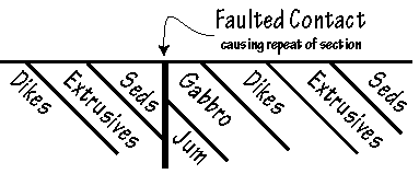
We're going to be in gabbro the next time we see a rock, and this spring-bounded area probably marks the faulted contact between the sediments and the intrusive gabbro. This is a big time structural contact, and represents significant disruption of the ophiolite stratigraphy. Think about it. We're jumping from the uppermost portion of the ophiolite to near its base, and all the stuff that used to be in between is now missing. And it's even more than that. This fault is actually responsible for repeating the entire section, as shown in the accompanying graphic. Structural dislocation of this magnitude always leaves me a bit humble as I consider the immense power of the tectonic processes which shape our planet. You'll note that the first gabbro outcrops that we come to are somewhat broken and shattered (just like the sediments on the other side). As we discussed then, this is probably due to proximity to this major break in the crust.
Mileage 0.65: On ridge
Bear left to stay on Road 18N17.
Mileage 0.9 Gabbro
While most gabbro is dark gray to nearly black, you'll notice right away that this exposure has much more of a "salt and pepper" appearance. This has a lot to do with the plagioclase feldspar - in this section it is nearly white, which imparts a much lighter coloration to the rock. In any event, here we are in the magma chamber (anybody notice any flashing lights?). This is a great exposure - lots of rock to look at and a heck of a view southeast down Monkey Creek towards the main fork of the Smith River. The Smith has to be one of the cleanest and most undeveloped river systems in the United States, and the main purpose of the Smith River National Recreation Area is to keep it like this. The way I understand it, this designation protects the Smith, and all of its tributaries, to the full extent of their drainage basins. This covers a lot of territory, and effectively limits development, logging, mining, exploration, and other surface disruptions forever (or at least until economics dictate that the rules be changed... again). It is important to note that one of the reasons that the Smith is so undeveloped is that much of the area is underlain by ultramafic rocks. As we know, these rocks have a hard time supporting lush forests, so logging has been minimal in many portions of the Smith drainage basin. But the ultramafics are the source for many of the critical metals which all industrialized nations require. At this time we get most of these metals (nickel, chromium, cobalt, and others) from foreign countries. But remember: there isn't much of this kind of rock exposed in the United States (or anywhere else for that matter). If the producing nations (Zimbabwe, South Africa, Canada, Russia, Zaire, and others) decide to mess around with the economics, or cut off our supply completely, there are very few other places our nation can go to obtain the necessary metals. "Learn to live without them," I hear several of you cry. Unfortunately, that really isn't a viable option if we want to continue to have such things as cars, refrigeration, modern medical facilities, shoes, computers, and all the other industrial society type stuff. The Smith River drainage contains a significant portion of our domestic reserve, and the time may come when political and economic pressures cause America to reassess its land-use priorities (...again).
There will be several side roads for the next mile or so - just stay on main road and you'll be fine.
Mileage 2.25: major 4-way crossroads
Continue straight to Monkey Ridge.
Mileage 2.6: Saddle on ridge
This is where the ridge road access joins Road 18N17. If you are walking in from there, welcome back to the tour. Stop and take a (short) break. Several roads meet here - stay on the main road heading east.
Mileage 2.85: Start uphill
Good news! We're back into ultramafics again. We're on the edge of a very structurally complex area within the Josephine Ophiolite. To the south the stratigraphy is relatively complete and undisturbed - you can literally walk from the top of the sediments down-section to the ultramafics (if you aren't daunted by the 40 degree slopes and thick brush on Monkey Ridge). But north of here it's a real mess, with lots of faulting and missing pieces. I first saw this in detail while mapping the stratigraphy at the Turner-Albright. The deposit is situated near the base of the extrusive lavas, 50 to 200 meters above their gradational lower contact with the sheeted dike sequence. But in the immediate vicinity of the deposit most of the rocks normally found below the extrusives are missing due to faulting which has shoved the uppermost portion of the extrusive/sheeted dike transition zone against serpentinized peridotite. Compared with the total section as exposed south of here, up to 1.5 kilometers of the ophiolite is missing, including the middle and lower sheeted dikes, all the gabbro, and an unknown quantity of peridotite.
Mileage 3.4: Contact zone
Somewhere around here we fault back out of the peridotite and into the sheeted dike complex. Are you tired of faulted contacts yet? Tough luck! I have never seen an ultramafic contact which wasn't structural. I don't think they exist. Sorry, it's just the way it is.
Mileage 3.7: Lower sheeted dike / gabbro transition zone
Well, here we are. This is truly a world-class exposure of the lower sheeted dike transition zone. The wide spot we're on is actually an old log landing from when they clear-cut the hillside below the road (there are still several logs left on the landing). With good parking and a killer view of the headwaters of Monkey Creek, this stop should be on everyone's list of places to visit before they head off to that great rockpile in the sky. Spend some time digging through the talus piled up at the base of the roadcut. Note the wide variations in texture from one rock to the next. Now wander about on the roadcut itself and look at this stuff in outcrop. It's pretty clear that we're seeing dikes cutting through coarser grained gabbro (or through other dikes). We call the dikes "dikes," and the little bits of remaining gabbro are called "screens." Dikes and screens. Dikes and screens. And more dikes and screens. And chill margins. These are really important because they mark the boundaries between individual dikes. Be sure to notice the distinctive pale-green color on some of the very fine-grained dikes along the chill margins. Learn to recognize this color - it's often the only indicator of dike margins. This becomes increasingly important as we move up-section. As we lose the gabbro screens we no longer have the textural variations to help indicate that we're in the sheeted dikes, and we're going to need all the help we can get to identify where we are in the ophiolite stratigraphy.
Mileage 4.0: Lower sheeted dike / gabbro transition zone
Another excellent exposure of the lower sheeted dikes. Imagine trying to figure this out without the roadcut. Walk up above the road and look for pieces of float lying about in the bush. Coarse grain. Fine grain. Coarse grain. Medium grain. Very confusing. Let's hear it for roadcuts!
Mileage 4.55: Side roads
Stay on main road (in the center) to continue south along Monkey Ridge towards the lookout site. We're moving slowly up-section into the sheeted dike complex.
Mileage 4.8: Sheeted dike complex
We're well into the heart of the sheeted dikes. Note the absence of gabbro screens. All we have left is dikes cutting dikes cutting dikes, with very little variation in texture. This is the plumbing system which connects the extrusive basalt with the magma chamber.
Mileage 5.8 to 6.0: Sheeted dike complex
Still in the sheeted dikes. It's a real challenge to identify individual dike margins. They can be very tough to spot, but with practice you'll find that it gets easier. Spend some time until you convince yourself that you know what you're seeing. Look for the pale green color of the finer-grained material along the margins. As mentioned above, it's can be one of the best ways to identify the borders of individual dikes. This is also a great place to look over the edge and imagine the joys involved in field work along Monkey Ridge. The whole area is steeper than the back of God's head, and so brushy that it's rare to be able to see in any direction for more than a couple feet. We spent several field seasons here in the early 1980's, attempting to follow the favorable horizon that hosts the Turner-Albright southward into this area. Our field crews cut nearly one hundred miles of line running east to west across the ridge so we could conduct geologic mapping, geochemical sampling, and geophysical surveys of the area. We were successful in tracing the lower extrusive / upper dike transition zone to the south, and actually defined two targets which warranted drilling. One of them was about 1500 feet to the southeast from here. The drilling program was completely helicopter supported (but the walks in and out were not!). Feel free to bail off the side of the road and look for the contact.
As mentioned above, Monkey Ridge one of a few places where you can actually walk through the complete ophiolite. Look to the east, way down at the bottom near Highway 199. If you start there you'll be in the upper sedimentary horizon. Bounce back uphill and you will actually be going stratigraphically down-section, through the sediments, into and through the extrusive basalt, and into the sheeted dikes. This gets you to where we are now. Heading downhill to the west takes you out through the base of the dikes and into the gabbro of the magma chamber. And when you get really west, you'll even fault back into ultramafics of the upper mantle. Feel free to try the direct route if you choose. We're going to see all the pieces on the tour, but it'll take a much longer route. It is, however, much easier on the legs! Try to get a feel for the size of the exposure. The earth is a big place, and we're going to see just a tiny bit of it on our tour.
Mileage 6.1: Sheeted dike complex
Another roadcut with several identifiable dike margins.
Mileage 6.45: Sheeted dike complex
This is an excellent exposure in the heart of the sheeted dikes, with many visible margins. Definitely worth a stop. Again, look for the distinctive pale-green coloration to help you find the edges of individual dikes.
Mileage 7.8: Monkey Ridge Lookout (site)
There used to be a fire lookout here, but it's gone and now there is only a radio repeater. But what a view! We'll turn around here (good idea, huh?), and head back to Baker Flat.
Reset trip meter to 0.0
Mileage 0.0: Baker Flat
Continue south towards Patrick Creek and Highway 199.
Mileage 0.1: Basalt
We're going to be seeing quite a bit of this stuff for the next several miles so get ready.
Mileage 1.0: Manganiferous sediments
This is another of those times when enough sedimentary material accumulated to be significant. This exposure is doubly so because of the nature of the sediments. Notice how black they are? The color comes from a fairly anomalous amount of the element manganese which is contained within the sediments. For various reasons, this exposure has caused numerous geologists to get pretty worked up over the past several decades (breathing hard, walking on their tongues, and so on). This is partly due to the unusual nature of the material, and partly due to the possibility of gold occurring along with the manganese. Personally, I don't get too excited by manganese, and since the assays for gold have been routinely disappointing I fail to share their enthusiasm for the outcrop. It does serve as an excellent example of how some pretty strange stuff can accumulate on the seafloor and become part of the geologic record. Imagine the layer that's going to represent our tenure on the planet!
Mileage 2.0 to 2.6: Basalt
There are several excellent exposures along this stretch of road. Basalt has many different faces, and many of them can be seen in this area: thin, broken flows (lots of these); thick, massive flows (see mileage 2.9 for a great exposure); breccias of several sorts; and even some rough pillows. You can kinda/sorta see them at the beginning of this section (mileage 2.0 to 2.2). If you squint one eye and don't look too hard out of the other you can identify crudely spherical forms which almost certainly represent a rough attempt by the earth to make pillows. Nowhere near as good as the exposures at the Turner-Albright or south of Roseburg, but pillows nonetheless. We can also see the pale-green color that we learned to love in the sheeted dikes. It seems that this color is distinctive of fine grained mafic rock: common to dike chill margins... and the quickly-cooled rims of pillows. Look carefully and you'll see it, mostly associated with fragments in breccias (remember our discussion of the cooled pillow rims and how they break off to make "inter-pillow breccia").
This is also a good time to talk about that joy of the woods: poison oak. One of the few redeeming values of the ultramafics is that the soils which they produce do not support poison oak. Not so with the mafics. Here we are taking a pleasant stroll in basalt and there's that damn stuff all over the place. Leaves of three, let them be! If you get poison oak, now's the time to be careful. If you're immune, well, this is a PG-13 site and I need to keep it clean so, to paraphrase Bigwig, "silflay hrakka and go tharn, you embleer frith!"
Mileage 2.9: Basalt
A sharp bend to the right with a good turnout. Park it for a bit and let's look at some rock. Walk back up to mileage 2.8 and look for more pillows. They're still pretty rough, but visible if you look hard enough. The basalt at the turnout is as massive as we've seen, and there's even a large paper hornet's nest right in the center of the roadcut (as of July 1998). Poke it with a stick and get some personal experience in another of the joys typical to any work in the Josephine Ophiolite.
Mileage 3.15: Divide between Shelly Creek and Patrick Creek
This is a very distinctive topographic feature, and it's tempting to blame it on faulting. There are good outcrops on either side of the saddle, but at first glance there is no obvious change in lithology (rock type) to support this hypothesis. A closer look reveals some clues, however. The rock in the saddle itself looks to be shattered, like you would expect from faulting, and there are some small differences in the rock. We've been in basalt on the north side for several miles, and the rock south of the saddle is also mafic. But the texture seems a bit coarser, the soil a slightly different hue, and there are subtle but persistent textural variations as we move south. My gut feeling is that we just faulted into the lower sheeted dikes, but I'm not sure. This is another of the joys of working in the Josephine Ophiolite. Since most of the rocks are compositionally the same, in many places the fundamental question is not "what is it," but "where is it." And it's not always easy to tell!
Mileage 3.4: Possible dikes
Still looks too coarse to be basalt, and a close look at the outcrop turns up some possible dike margins. I still like the lower dike / uppermost gabbro interpretation (but am still not convinced).
Mileage 4.1 to 4.2: Ultramafics
Within a 2 mile radius of here, we could see all of the ophiolite-related rock types, but not stratigraphically in place like we saw along Monkey Ridge. We're on the edge of a very structurally complex area - lots of faulting has moved pieces of the ophiolite all over the place. And here is one of them now. Where did this serpentine come from? If you look south through the trees to the other side of Patrick Creek, the sparse vegetation should tell you that the southwest side of the creek is underlain by ultramafics.
Mileage 5.7: Junction with Gasquet Toll Road
This is pretty much where the original Wimer Road ended, and the Gasquet Toll Road began. The Smith River Canyon was just too rugged for a road, so the engineers of the late 1800's built away from the river (the present Smith River route wasn't constructed until 1926). Horace Gasquet opened the original section between Patrick Creek and the town of Gasquet in 1887, completing the link between Crescent City and the gold fields of Oregon. Mr. Gasquet's tolls were a real bargain - $.25 for a footman, $1.00 for a man on a horse, $.06 for hogs and sheep, $.125 for cows and loose horses, and $2.75 for a one horse vehicle. Feel free to turn right, and follow the signs to the west end of the road in Gasquet. It's a very long drive through more ultramafics. The rest of us are going to bear left and head down Patrick Creek to the Smith River.
Mileage 6.4: Campground
Small camping area on Patrick Creek.
Mileage 7.35: Ultramafics
When did we fault into these? Did you make note of the contact? This exposure is larger than the last one (at mileage 4.1 to 4.2), and extends to the southwest for many miles. We're going to head north and east back into the upper portions of the ophiolite.
Mileage 8.7: Mouth of Patrick Creek
Junction of Patrick Creek Road and Highway 199. The original Patrick Creek Lodge was actually built farther up Patrick Creek along the Gasquet Toll Road. The location wasn't moved here until 1926 to take advantage of the new modern highway which had just been completed on the Smith River.
Reset trip meter to 0.0 and turn north (left)
Mileage 0.0: Junction of Patrick Creek Road and Highway 199
Heading north towards Oregon.
Mileage 0.95: Depositional contact - Galice Sediments and Rogue Volcanics
If you were to look for the "expert" on the Josephine Ophiolite it would have to be Dr. Greg Harper from the State University of New York at Albany. Harper did his doctoral work on the ophiolite in the late 1970's, and pretty much wrote the bible on the Smith River section. This is one of his classic sites, and has been held up as evidence for several regional theories that are still valid today. Be very careful with the road in this area - it's narrow and windy, but as fortune would have it there is a large turnout/parking area on right side as you are heading up river (it's the only wide spot around and is also the location of Call Box #199-232). Take the short trail to the Smith River from the parking area. When you reach the water you will be in sedimentary units of the Galice formation - polished and river-worn and looking great. If you walk downstream for approximately 100 meters it will be clear that you are also walking down-section, because suddenly you are in basalt of the Rogue Volcanics. It's real obvious - the rocks look different and even the shape of the land reflects the change in lithology. The floodplain is relatively wide in the sediments, but the volcanics must be more resistant because the canyon narrows and becomes much steeper below the contact.
The contact itself is wonderful - well exposed along the river and clearly depositional. What this means is that the sediments were deposited directly on top of the volcanics. You can also see very well developed pillows mixed in with the basalt flows.
One of the things proposed after looking at this site was the behind-the-arc spreading model for the Josephine Ophiolite, and its relationship to the volcanic arc rocks found in the Galice area (the second part of our tour).
Mileage 1.55: Mass wasting in action
As discussed above, this is a very wet climate and most winters will contain periods of time when Highway 199 is closed due to slides and other mass wasting processes which move large amounts of rock from the hillsides and deposits them on the road. The winter of 1997/98 was no exception, and this slide effectively closed 199 for a week or so. The bedrock in this area is sedimentary, with a high degree of folding which was evident when the cut was still fresh.
Mileage 2.7: Mouth of Monkey Creek
From here north, faulting has complicated the expected ophiolite stratigraphy and we will soon be back down-section in sheeted dikes.
Mileage 3.0: Siskiyou Fork
This is about the location where the Siskiyou Fork and the Smith join on their journey to the beach. The interesting part about this stop is the ridge of land between the two rivers. You can kinda/sorta see it from here. I saw an aerial photo taken several days after the crest of the December 1964 flood has passed, and the area was still covered with water. That was some flood!
Mileage 4.8 to 5.5: Sheeted dikes
A section with several excellent outcrops in the roadcuts. The exposure pretty much ends at the Idlewild Maintenance Station which is on the left just beyond mileage 5.6. You can park there and carefully walk back along the highway, or pick your spots as you drive by. These are some classic sheeted dikes, but similarities in composition and texture can make them very difficult to identify. I've shown hundreds of people the dikes along this stretch of road (lots of them real geologists), and many leave unconvinced that they are seeing what they are seeing. Don't panic, and try not to get too frustrated. As a whole, the orientation is fairly steep. Look for chill margins as indicators of the edges of individual dikes, and subtle textural variations will help in some cases.
Mileage 8.85: Oregon Mountain Road
Junction with the old highway . Take it if you have the time. It's nearly 7 miles long and in sediments all the way (graywacke and shale). As far as the rocks are concerned, it doesn't matter which road you choose. From here north, the whole way to O'Brien, we're back at the top of the ophiolite in Galice sediments. Pick a turnout and look. Typical graywacke and shale (again!).
Mileage 11.0: Collier Tunnel
Honk your horn. This cuts nearly 4 miles from the trip over Oregon Mountain, but the time savings is even greater. The engineers who designed this thing sure needed a geologist. Part way through they hit some very unstable ground (not surprising since they were in sedimentary rock). There was a big cave-in and several casualties.
Mileage 12.45: Oregon Mountain Road
The north end of the old highway.
Mileage 19.1: O'Brien, Oregon
Junction of Lone Mountain Road and Highway 199.
End of the Smith River section of the tour.
The Galice Section
This tour will spend some time in rocks which were being formed to the west of the main ophiolite exposure we explored in the Smith River section. There will be several more exposures of ophiolitic rocks at the beginning, but much of what we will see as we head west was part of a chain of volcanic islands which were the result of subduction of the crust immediately west of the behind-the-arc spreading ridge which formed the ophiolite. I am also including a short side trip to view granitic rocks which may have formed within the core of a volcanic arc.
To begin this portion of the tour, get on Interstate-5 in Grants Pass and travel north for approximately 3 miles to the Merlin exit (Exit #61). Take the offramp and turn west towards Merlin and Galice. You should reach the corner of Merlin-Galice Road and Monument Drive in about a quarter of a mile.
Set trip meter to 0.0
Mileage 0.0: Corner of Merlin-Galice Road and Monument Drive.
If you have some extra time, be sure to turn right on Monument Drive and proceed north for about 0.25 miles to the Oregon Department of Geology and Mineral Industries (DOGAMI), which, along with the Oregon Department of Forestry, is on the right. DOGAMI has maps, books, articles on all aspects of Oregon geology, and a mineral and rock display which more than pays for the trip.
If you go to DOGAMI, be sure to reset your trip meter to 0.0 when you get back to the corner of Merlin-Galice Road and Monument Drive.
Mileage 3.6: Robertson Bridge Road
Corner of Merlin-Galice Road and Robertson Bridge Road. A left turn will take you to the Robertson Bridge crossing on the Rogue River. We're going to continue straight on Merlin-Galice Road.
Mileage 4.4: Azalea Drive
Corner of Merlin-Galice Road and Azalea Drive at the Louse Creek bridge. A left turn here will take you back into Grants Pass. Again, we're going to continue west on Merlin-Galice Road (leaving Merlin and heading towards Galice - proving that the highway dudes are nearly as clever with naming things as are geologists).
Mileage 6.1: The Shale Pit
This is private ground, and if you decide to trespass it is very important that you are respectful of any machinery which may be sitting in the quarry. But there is really no reason to have to violate property rights. There are several more outcrops a bit farther up the road - this one just has the best exposure. No matter what you do, stop and at least look at the back wall of the cut from the road.
These are obviously sedimentary rocks, and sure enough they have been assigned to the Galice Formation. There are several rules when it comes to naming formations. The first word relates to where the most "typical" exposure can be found. In this case it's in Galice (just up the road from here), so we can assume that the sediments we're going to be driving through during the tour are among the best that the Galice has to offer. The second name (in this case "Formation") is used to describe the dominant rock type to be found in the formation. If it's mostly shale, the second word would be "Shale." If it's mostly sandstone, the second word would be "Sandstone." And so on. If, however, there is no dominant lithology and the formation is a mixture of several different rock types, the second word is just "Formation." In the case of the Galice, where the rocks are rhythmically bedded graywacke and shale, we have to use "Formation." So, with all of that being said, why isn't there any graywacke in the shale pit? This is yet another example of how Strickler's 1st Law of GeoFantasy can help you keep from going crazy in the field.
As discussed above, graywacke and shale are both clastic sedimentary rocks which are derived from the compaction and cementation (lithification) of sediments transported by rivers to the ocean, where they sort themselves by size and pile up on the seafloor. The bigger stuff (sand) settles out close to shore and lithifies into sandstone (or graywacke, depending on several factors). The finer clay-sized particles remain suspended in the water until the energy drops enough for them to also settle to the seafloor. This usually occurs farther offshore, so the shale which is produced generally represents relatively quiet, deep water deposition.
Shale makes great road rock, which is why this is a pit and not a hillside. Since shale has already been chemically weathered to clay, it is actually relatively resistant to additional weathering when exposed at the surface. Not so with graywacke, which contains all sorts of partially weathered mineral and rock fragments, and quickly falls apart when subjected to the wind and rain common to this area. Anyway, many of the gravel roads in southwest Oregon are surfaced with crushed shale. But sometimes this can backfire. I worked with a catskinner once who was into the road business. He had surfaced several miles of road for a customer, only to find out later that the shale which he had used was contaminated with very fine particles of... gold! If you can believe the story, the customer calculated how much the gold in the road was worth, and factored that against what it would cost to rip it back up and re-surface with barren shale. The numbers worked out right, so they did it! Gold fever is not a pretty sight (and there is no known cure).
Now for the bad news. This is not really shale! It was, but not anymore. When the sediments were originally deposited, it was a pretty thick pile, and where we are now was buried beneath many hundreds of feet of additional material. As these layers of clay were buried deeper and deeper, they lithified and turned into the sedimentary rock called shale. But as deposition continued and the depth of burial increased, heat and pressure rose and the shale began to change. What we have here now is actually somewhere between being shale and "slate" - a low-grade metamorphic rock produced by adding a little bit of heat and pressure to shale. The metamorphic process involves changes in mineralogy, but in the case of slate the changes are so small, and the grain size of the minerals is so small, that it is usually pretty hard to see the mineralogical differences. However, at this location some of the original clay was altered to graphite - the mineral that they make pencils out of. If you pick up and handle some of this stuff, you will probably leave a gray smudge on your fingers. That's the graphite. Another indication that this section has been heated and squeezed is how the layers of shale/slate have been bent and folded. If you look real close you can see these folds - a sure indicator of burial and directed pressure.
Well, it's slate. Shale we go?
Mileage 8.2: Hog Creek Boat Landing
Park at the top and walk down to the river. This is a great place to put into the Rogue for a day's float. It's also a great place to see some more Galice Formation sediments. Still lots of shale, but also some layers with larger fragments - we call this coarser rock graywacke. Walk back along the road to the upper parking area, stop at the switchback, and look into the bushes. You can see river gravels deposited on top of sedimentary rock. If you look carefully you can find a small excavation at the base of the gravels where they are in contact with the sediments. I'm pretty sure that this is a small exploration pit dug in the search for gold. The Rogue River has been transporting gold for millions of years, and some very rich deposits have been mined in the Galice area from "Old Channel" gravels. This one must have been a bust - if the prospector had found much gold I imagine that the hole would have dramatically increased in size!
Immediately west of Hog Creek the local lithology becomes structurally complex - lots of faulting has moved the pieces around. Sediments, basalt, ultramafics, basalt, ultramafics, basalt... and so on. A real dog's breakfast! The first course comes almost immediately, when the road enters a deep cut with bold outcrops of ultramafics and basalt. You're going to want to stop, but don't. It's very narrow and far too dangerous. We'll have plenty of opportunity to see these rock types later.
By the way, I'm assuming that you parked in the upper parking area and that the error in mileage will be minimal (we're going to reset in 4 more miles anyway). But, if you drove down to the boat landing the bust in mileage may be significant, so be sure to account for this as you continue from here.
Mileage 8.9: Hellgate viewpoint
Stop and take a look. This is one of the more famous stretches of the Rogue River, and was even featured in a John Wane film when the Duke floated through on a raft with Kathryn Hepburn, with the bad guys in pursuit.
Hellgate canyon is cut in basalt. It's quite deep with some pretty strange currents. These basalts are similar to the material we saw associated with the ophiolite in the Smith River section, so we won't spend a bunch more time discussing them.
Mileage 9.6: Hellgate Bridge
There is a wide turnout to the left before you cross over the bridge. Park here, as close to the east end of the turnout as is convenient (away from the bridge).
Let's walk across the road and look at some rock. If you're at the east end, you should be in basalt. But look closely: these are not flows or pillows. The outcrop seems to be composed of small, angular fragments which piled up and were lithified into rock. We call these angular fragments "breccia," and since they were derived from volcanic processes we will call the overall rock a "volcanic breccia." Would these also be considered a pyroclastic? I would probably not lump them into that category because I'm not convinced that they were the result of an explosive event. They are more than likely just an accumulation of volcanic rubble on the seafloor.
Pick your way west along the outcrop (towards the bridge). Being as observant as you are, you will soon notice that the rock becomes more fractured and the degree of brecciation increases, to the point where we can see breccias within breccias. Something must have happened which led to post-lithification brecciation (translation: after the breccia fragments were consolidated into rock they were broken again... and then re-lithified). Keep walking west. Suddenly, we're no longer in volcanic breccia. The lithology has changed and now we're in serpentinized peridotite. Basalt to ultramafics. What type of contact would you expect in this situation? If you said "faulted contact," you have a good memory from what we discussed on Baker Flat. At that location the contact was obscured by dirt and vegetation. We couldn't see it, and were even somewhat uncertain as to where it actually was. The good news is that this time we can see the actual contact. Cross back over to the parking area and look across at the outcrop so you can see the contact from a distance. The fault itself in not a single break, but actually a zone of shearing 4 to 6 meters wide. The main break (on the west) dips steeply to the east, with several sub-parallel shears to the east in the volcanics. Now go back across for a closer look. Starting on the west, the main fault is a real mess, with lots of shearing and even some asbestos within the break. There is also some powdered magnetite along the fault, which you can pick out with any small magnet. The wider zone of shearing eastward in the basalt shows extensive brecciation, with lots of small faults and breaks. This is a major structure, and represents large-scale disruption of the expected ophiolite stratigraphy.
Let's go a bit farther west and look at the ultramafics. This is a great exposure, and many of the features which are common to serpentine are visible along the roadcut. Remember when we talked about the internal readjustments needed in order to accommodate the increase in volume which was caused by the hydration of the peridotite? You can really see this here, and it is easy to pull out small nodules of serpentine which have been smoothed on all sides by this shearing. Look at the color of the rock. Serpentine can be black, almost white, and all possible shades of green. It can even be translucent, which means that light will pass through it. Some of the prettiest gold ore I ever saw was from Peter and Paul Mountain, about 25 miles east of here. The deposit was in ultramafics, with the gold occurring as "gold leaf" which had been smeared between the smooth, translucent surfaces of individual serpentine nodules. Very showy. You will also notice several light-colored, very fine-grained dikes cutting through the serpentine. In cases like this when it is impossible to determine the actual mineralogy, geologists use the field term "aplite dike" to refer to these light-colored, fine-grained dikes.
Lastly, this is another place to view the wonders of ultramafic soils and the effect they have on vegetation. Look around you on the hillsides. Think you could roughly map in the contacts? Walk to the east end of the bridge and up Stratton Creek Road for a bit. What an exposure. Again, look at the vegetation on the surrounding hillsides. Now look farther west. Based on vegetation patterns alone, how much longer do you think we'll be in ultramafics?
Mileage 10.1 to 10.2: Contact zone
If you said that another change in lithology was imminent, you were right. Somewhere through here we are going to fault out of the ultramafics and back into basalt. This contact is again obscured by the realities of surface weathering. Stop and look for it if you choose. You should be able to narrow it down.
From here to the mouth of Taylor Creek there are several excellent exposures of basalt (the best are from mileages 10.9 to 11.1, and from 11.4 to 11.6). Stop and check some of them out. Note that these are mostly massive flows and volcanic breccia, with only crude pillow forms in random areas.
Mileage 12.0: Taylor Creek
This is the mouth of Taylor Creek and the junction with Briggs Valley Road (Road #25). For a great side trip, reset your trip meter, turn south up Briggs Valley Road and travel 2.3 miles to the Taylor Creek Gorge overlook. It's paved the whole way and there's even a good turnaround at the small parking area which will be on your left. Check out the sedimentary rocks on the way up Taylor Creek. We'll be back in basalt soon enough but this is another good exposure. When you get to the parking area, walk down to the observation platform. The stairs to the overlook are paved with schist (a metamorphic rock). What a view! Let's talk about geomorphology (geo = earth; morph = shape; ology = the study of: so geomorphology is the study of landforms on earth). If you look at the general shape of the valley walls, you can see how the bottom hundred feet or so are nearly vertical, with a more V-shaped cross-section above that. This is a great example of "stream rejuvenation," with rapid downcutting in response to a change in "base level." All rivers will erode their beds until they reach their base level. The ultimate base level is the ocean, but there are many temporary base levels that control the energy and erosional capabilities of most streams. Taylor Creek's base level is the Rogue River, and if the Rogue goes up or down, the energy of Taylor Creek changes to reflect the new base level. Anyway, it looks as though the Rogue River and Taylor Creek area had kinda/sorta stabilized, and "back-wasting" along Taylor Creek had begun to eat back into the canyon walls, creating a V-shaped valley (common in youthful mountain streams). But then there was a change in the Rogue's base level, causing it to downcut. This led to an increase in the gradient of Taylor Creek, causing active, rapid downcutting into its bed. This is still going on, and is carving the steep canyon walls we see at the bottom. When Taylor Creek again catches up to the local base level, back-wasting will begin to exceed downcutting and a V-shaped valley will once again begin to form.
Reset your trip meter to 0.0 before you start back down.
Additional support for this GeoFantasy can be seen as you drive back down towards the Rogue. At about 0.95 miles, pull into the small turnout and stop (be careful: it's steep and you really don't want to drive off the cliff). Look across Taylor Creek and you will see the general area where Schoolmarm Creek flows into Taylor Creek from the other side of the valley. Actually, it "falls" into Taylor Creek. If you look carefully, you will note that the upper portion of Schoolmarm Creek has a relatively gentle gradient and V-shaped side walls, and that this elevation roughly corresponds with the upper V-shaped portion of Taylor Creek we discussed at the overlook. When the local base levels were stabilized, all three streams (Rogue, Taylor, and Schoolmarm) had relatively low gradients and back-wasting had begun to produce V-shaped valleys. Then the change in base level occurred. With its greater volume, Taylor Creek has managed to keep up with the new level of the Rogue and maintain a relatively low gradient (but with very steep canyon walls - still no back-wasting). However, Schoolmarm Creek, with its much lower flow, can't keep up with Taylor Creek, and has yet to downcut to its level. These "hanging valley falls" are most common in glaciated areas like Yosemite Valley, but can also be seen in situations like this.
Reset your trip meter to 0.0
Mileage 0.0
Junction of Merlin-Galice Road and Briggs Valley Road at the mouth of Taylor Creek.
Mileage 2.9: Galice Creek
Mouth of Galice Creek, and we're back in sediments again (remember, they ARE called the Galice Formation). We sure do seem to be bouncing around within the expected stratigraphy. Sediments, then basalt, then ultramafics, back into basalt (with sediments), and now sediments again. Just like we talked about in the Baker Flat area, what we have here are several faults which have repeated the stratigraphy. The good news is that we are pretty much done with the ophiolite and have come far enough west to begin seeing material associated with the volcanic arc.
Mileage 3.15: Galice, Oregon
Welcome to downtown Galice. Stop for lunch and a cold drink at the store/cafe (if you can find a place to park). I recommend the "Chef's Sandwich," but it's all good food. While here, take a look at some of the pictures on the walls (inside and outside). Many shots are originals from the early days of logging and gold mining in this area. There is also a picture, inside the main door, which was taken during the flood of December 1964. Omagosh. By the way, this was the same storm that we talked about along the Smith River at the mouth of the Siskiyou Fork. The 1964 event was considered a 100 year flood, and it's a damn good thing they don't come more often. What happened in 1964 was incredible. A strong jetstream brought heavy snows out of the Gulf of Alaska in early December, and buried the mountains of the Pacific Northwest in the white stuff. Then an unfortunate shift in the jetstream set up what is called "the pineapple express." This occurs when the winds veer to the southwest and warm, moist tropical storms slam into northern California, Oregon, and Washington. I was told that there was more than 15 feet of snow at Crater Lake when the rains hit. Oops. Intense rainfall began around December 20th, and by the 23rd all the snow had been removed, adding this water to rivers and streams already swollen by the heavy rains. And a Merry Christmas to all! But the earth really doesn't care if it's Christmas, or Easter, or Groundhog Day. In fact, the earth doesn't really give much of a thought to us at all. Sorry if that hurts your feelings, but that's the way it is.
Mileage 3.8: Galice Sediments
If this isn't the type location which gave the sediments their name, it's close enough to serve the purpose. Graywacke and shale, graywacke and shale... and more graywacke and shale. We've talked this stuff to death, so just look for a bit and try to absorb some of the magic of clastic sedimentary rocks.
Mileage 5.75: Rand Ranger Station
Rand Ranger Station and Visitor Center. This is the place to get permits for floating the Wild and Scenic portion of the Rogue River (beginning at the mouth of Grave Creek).
Mileage 6.7: Almeda Mine
Okay, a fundamental change and several new topics to discuss. Get comfy 'cuz we'll be here for awhile. If you look across the river, it's pretty obvious that mining took place at some time in the past. This is the Almeda Mine, which was intermittently active in the early 1900's. Nearly 17,000 tons of ore were mined, yielding a reported 259,800 pounds of copper and 48,387 troy ounces of silver, with additional values in gold and lead. The mine was developed on several levels (you can still see some of the adits), with the deeper workings extending well below the elevation of the Rogue River (these are now flooded). Just like at the Turner-Albright and Monumental, this deposit is highly siliceous and the ore minerals are sulfides - metals combined with sulfur. As usual, there was more iron than anything else, so the main sulfide is pyrite (FeS2 - one atom of iron combined with 2 atoms of sulfur). But there is also chalcopyrite (CuFeS2 - pyrite with one atom of copper) and galena (PbS - one atom of lead and one atom of sulfur). Silica occurs throughout the main ore horizon, as well as lateral to the ore horizon and below it in a "silica stockwork," which may represent the feeder system for the mineralizing fluids. Is this setting similar to the black smoker hydrothermal vents we find along spreading ridges? Probably, but there are several differences which we will get to in a minute. The deposit is currently inactive, but ore still remains underground and exploration continues from time to time.
Stratigraphically, it's pretty simple. We are at the top of the Rogue Volcanics, immediately below their depositional contact with the overlying Galice Formation. When we saw this contact along the Smith River the volcanics were a mafic pillow basalt, but here they look completely different. One difference is obviously the silica and sulfide mineralization, but there are also some fundamental differences in the host rock as well. This stuff is not basalt, but much more felsic. It is also clearly fragmental, with clast sizes ranging from ash to larger brecciated chunks. This is not part of the seafloor! Most likely we are standing on the edge of the volcanic arc. These types of volcanoes are generally more intermediate in composition, and therefore more explosive (like Mt. St. Helens). However, both felsic and mafic magma can also be vented (again confirming the 1st Law of GeoFantasy). Where we are now standing looks to have been on the receiving end of an explosive felsic eruption which deposited a thick pile of pyroclastic debris. This must have also been the last eruption in this area, because the volcanics were soon covered with sediments of the Galice Formation. A happy coincidence, but these things happen. When did the silica and sulfides arrive? This is a good question which may be impossible to answer with any degree of certainty. It's tempting to bring them here via hydrothermal vents while the volcanism was still active, but they may have come later, even after the deposition of the sediments (unlikely, but possible). We may never know for sure.
Look along the roadcut for the contact. I said above that it is depositional, but that is actually not possible to confirm at this location. Sometime between the formation of these rocks during the Jurassic, and the construction of the road, a thick dacite dike was intruded along the contact (dacite is an intermediate igneous rock). There are several of these dikes within the volcaniclastics, and the fact that they show no evidence of silica or sulfides dates them as post-mineralization intrusive events (according to the law of cross-cutting relationships).
Walk west along the roadcut and see what happens to the rock. Remember that you are walking down-section, deeper into the pile of material built by the volcanic arc. If the mineralizing fluids came from below, they probably passed through these portions of the stratigraphy. And sure enough, there is a significant amount of silica and pyrite for several hundred feet. This may represent the silica stockwork plumbing system for the hydrothermal vents. Keep walking west. There is a gradual loss of silica and sulfides. You will also note that the chemistry of the rock changes, becoming more intermediate in composition, and ultimately becoming mafic. We will be in relatively mafic material for the remainder of the tour. This makes the felsic pyroclastic horizon which hosts the Almeda deposit a real oddity for this volcanic area. The interesting part is that whatever caused it was pretty big. This uppermost volcanic horizon, called The Big Yank Lode, is over 30 miles long and can be traced for quite a distance to both the north and south. The Big Yank is mineralized throughout its extent, and many smaller deposits exist. The full extent of this remarkable horizon has been the focus of extensive exploration for many years.
Mileage 8.7: Interflow sediments
We've been in volcanics since the depositional contact at the Almeda. So what are these sediments doing here. Just like we saw at several locations in the Smith River section, what we have here are sediments which were deposited between times of active volcanism. Look how steeply they are dipping - almost vertical. We may be in them for several hundred feet along the road, but the true thickness of the sediments probably isn't much more than 15 feet.
Mileage 10.2: Mouth of Grave Creek
We're at the mouth of Grave Creek, and the end of our driving tour down the Rogue River. Still in basalt and interflow sediments. You have 3 roads to choose from: back the way we came, northwest (to the coast), or northeast (up Grave Creek to I-5). But there aren't any roads which follow the Rogue. This is the start of the Wild and Scenic portion, and permits are required to float the river between here and Agness, approximately 40 miles west. There are two trails which head down river from here. The shorter trail follows the south bank and ends at Rainie Falls. It's about 2 miles long and is a great walk. You can get right down to the falls, and if it's the right time of the year you can sit at the edge of the water and watch the salmon try to make the 6 foot jump. The longer trail on the north side, which starts at the boat ramp and follows the river to Agness, is the only way (other than by boat) to see the Wild and Scenic section of the Rogue. If we were to head down river, we would continue to descend deeper into the volcanic arc, eventually coming through the base and into the remnants of the mafic seafloor crust upon which it was built. It's a great trip (and I hope to complete a GeoTour of this trail next summer).
Well, except for the granitics that's it. Retrace your route back to where we started at the corner of Merlin-Galice Road and Monument Drive. If you've had enough, you can wimp out there and turn left to get back to Grants Pass (if you do, click here to jump to the closing remarks following the discussion of the granitics).
If you still have enough juice to visit the granitics, continue east from the corner of Merlin-Galice Road and Monument Drive for 0.25 miles. Just after you pass under I-5 you'll hit the old highway. Turn right ("Right Turn Permitted Without Stopping"). Drive 1.5 miles to the top of the divide and the I-5 overpass. Just before crossing over the freeway, turn left into Rogue Valley Secured Storage. Please pay your respects to the owners (it's the polite thing to do), then drive to the back and park.
Side trip to granitic rocks
As discussed in the gabbro section, the origin of magma (especially the felsic variety) is one of those things in geology which is REALLY uncertain. Many different processes have been proposed over the years. At one point it was even thought that granitic rocks came directly from seawater, but this hypothesis is pretty far down on most geologists list of possibilities. But the discussion continues to rage, and it is probably beyond our ability to resolve it during this tour. Whatever the source of felsic magma, several observations point to an association with plate tectonics and subduction of the crust. The basic idea is that as mafic seafloor crust descends into the earth it is heated to the melting point and "purified" as differentiation is allowed to continue. The heavier mafic elements are selectively retained at depth and only the lighter, felsic material rises in the crust to eventually cool and crystallize into granitic rocks. There is also the possibility that some granitic magmas are derived directly from sedimentary rock as it is buried by additional layers of sediment, causing an increase in temperature and eventual melting to form felsic magma. Click here for more on plate tectonics and the formation of magmas.
Granitic rocks have a pretty specific mineralogy, and there are several pieces of good news: it's relatively simple, there are various shades of light and dark to keep it visually stimulating, and since granite is an intrusive rock the individual minerals are usually big enough to identify. The light (felsic) minerals are usually orthoclase feldspar and quartz, with the relatively small amount of mafic mineral commonly being biotite mica. As always, there are transitions. As the chemistry of the magma tweaks closer to an intermediate composition, amphibole (commonly hornblende) will substitute for some of the biotite, plagioclase feldspar will begin to substitute for some of the orthoclase, and there will be a decrease in quartz.
This is a great outcrop of granitics. The locals call it "Tombstone Granite," and even sell some of it for monuments and other decorative purposes. There is also a large local market for "Decomposed Granite," which forms by weathering processes as the material approaches the current surface of the earth. The formation of "DG" is a nifty process. If you remember from one of our stops on the Smith River tour (Mileage 2.0: Small bridge over a seasonal creek), minerals are subject to chemical weathering in roughly the same order as they occur on Bowen's Reaction Series. What this means for granitic rocks is that the mafic minerals (biotite and/or hornblende) weather first and turn into clay. This change involves an increase in volume, and the granite literally explodes at a bazillion places inside the rock. So we end up with piles of loose feldspar and quartz, with just a little bit of clay to keep them from falling completely apart. Since what's left is relatively inert, DG is great for tracks and baseball infields, and many use it as a filler for garden soils (but you have to add a bunch of mulch - other than slowly released potassium from the feldspar there isn't much nutritional value to this stuff).
If you take a close look at the granite you will notice dark, randomly scattered patches of a different type of rock mixed in with it. These mafic inclusions are called "inclusions" (another clever use of terms), or "xenoliths" by those looking to impress, or confuse, their audience. Whatever you decide to call them, their origin is another of the mysteries inherent in any rock which forms 3 to 5 miles below the surface. As we also discussed above, magmas form in magma chambers, which may or may not have sides or bottoms, but they almost certainly have tops. And sometimes pieces of the top (called the roof) detach themselves and fall into the magma. I know this sounds pretty weird and nearly impossible, but this process is thought to result in the inclusion of xenoliths in a cooling magma. And here they are, all cooled and hard and part of the rock.
When you leave this stop, turn left and continue south another 1.9 miles to Grants Pass.
End of the Galice section
Closing comments
Well, that's it. If you made it the whole way, thanks and congratulations. One last thing to remember: you haven't seen it all. You've just begun to scratch the surface of the earth, how it works, and what it's producing. It's a big world. Go out and look at it.
How about some feedback? Even if you didn't take the actual tour, but only read through the information, I would love to know what you think of my efforts. If you give me your name I'll even include you in the list of those who have "Survived the Josephine Ophiolite."