Almost everyone who has looked at a world map or globe has noticed that the continents of South America and Africa seem to fit together fairly well. An even better fit is obtained if continental margins (the underwater edge of the continent) are used. Other "fits" of this sort can be assembled as well. It is difficult to believe that this is purely accidental, yet it is equally difficult to imagine and support a theory that explains it.
It is one thing to notice a possiblity and another to take it seriously enough to seek evidence to support it. Alfred Wegener, a German meteorologist, decided to look for such evidence. He theorized that if South America and Africa had been joined at some earlier time, there would be similar geological formations such as mountain ranges which would extend from one continent to across the boundary. Simlarly, there would be fossils of extinct animals and plants distributed across the boundary. Marks left in rocks by glaciers would indicate similar glacial flow patterns.
Wegener carried out several successful expeditions in search of such evidence. Mountain chains extening from one continent to the other were found. Fossil distribution patterns supported the idea, as did glaciation patterns. It seemed that Africa and South America had been joined. Since they are not now joined, they have drifted apart, which leads to the term "Continental Drift" as a name for the process. Wegener proposed (1912) a superontinent named "Pangaea" which broke up to form the continents as we now see them. Wegener died in 1930 in Greenland.
While the evidence for Continental Drift is substantial, resistance to the idea was strong. This resistance is quite understandable, since it is difficult to imagine a continent moving. Not only is it a very large object, but it would have to plow through miles of solid rock at the floor of an ocean to change its position. Continental Drift was difficult to accept because it lacked a mechanism. Wegener's idea was regarded as interesting, but not accepted as a satisfactory theory.
The first evidence which eventually led to further development and acceptance of Wegener's ideas came not from research directed towards settling the issue, but rather from measurements of the magnetism of rocks. When molten rock cools near a magnet (the Earth's magnetic field), magnetic particles in the rock are trapped in the orientation imposed upon them by the magnetic field. They preserve a record of the direction of the Earth's magnetic field and thus the location of the magnetic poles at the time of solidification. When such measurements were made, it was found that either the poles were wandering erratically (and differently if data from differrent continents were compared) or the continents were moving. This gave support to the continental drift idea, but still a mechanism was lacking.
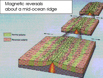
A glimpse of this mechanism came from studies of the magnetic characteristics of the ocean floor. During the 1950's, at least partly driven by the military need to understand the ocean as the arena of submarine warfare, intensive studies of the ocean floor were carried out. It was found that the center of each major ocean was occupied by a ridge at whose center was a valley. On each side of this, parallel stripes of rocks magnetized in opposite directions were found. The pattern of stripes on one side was the mirror image of the pattern on the other side. The reversal of the earth's magnetic field recorded in the rocks was repeated on each side of the ridge.
This led H. H. Hess (1960) to propose the idea of sea-floor spreading. Molten rock is continuously extruded and cools to form the ridge. As it solidifies, it records the magnetic field at that time. Since it spreads to each side of the ridge, each side has the same record magnetic field record (one is the mirror image of the other). Since new crust is being formed at the ridges, it must be consumed somewhere. Hess proposed that this happens at deep sea trenches, where oceanic crust "dives" under a continent.
These processes are illustrated below:

