An obvious case of a horizonatal temperature gradient would be, say over 1000 km EW, 500 km is over the ocean and 500 KM is over the land. Note that in the Summer this would be a ocean-land temperature increase, but in the winter that might be reversed.
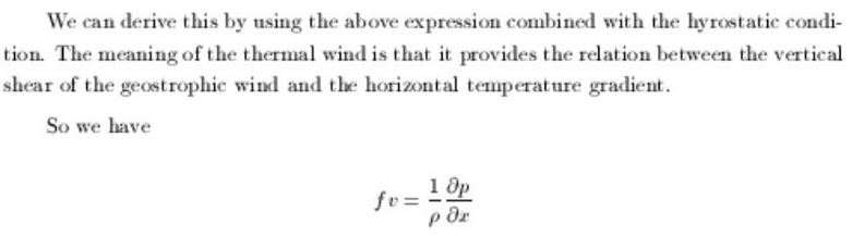
v denotes a vertical velocity in this case and x is a generic 1D coordinate.
This physical process is precisely that which drives the jet stream movement. A larger temperature gradient will produce larger vertical shear. Since the temperature gradient is larger in the winter than the summer, the het stream is strongest in the winter, as verified by observations
In general, climate change can serve to alter these large scale temperature gradients compared to their average values. Ocean warming might tend to reduce the gradient which would serve to
lower the geostrophic wind at increasing heights and there is some evidence that the Jet Stream is weakening - more on this later.
A numerical evluation of this expressions is useful:
- Use latitude of 45 degrees so f = 2Ωsinφ f = 10-4
- Consider it summer so use 300K as surface temperature
- Use temperature gradient of 1 K per 100 km
Gradient is then 104*(9.8/300)*(1/100) = 3.2 m/s per km
Jet stream is nominally at 10 km so this would be 32 m/s or about 65 MPH.
For winter T can be 250 K and gradient can be 2 K per 100 km; in this case the gradient is 7.6 ; substantially higher
There are many different ways to derive the thermal wind; often a vector approach is used (google on this if your interested) and in that case one can derive:
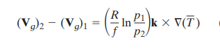
- Where the subscripts 1 and 2 refer to two different heights in the atmosphere which have two different pressures and two different wind velocities;
- R is the gas constant
- ∇T represents an average temperature gradient.
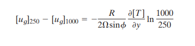
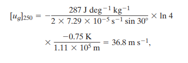
Based on this formulation we can do another numerical example for winter time:
latitude (y) is 30
temperature gradient is .75K per degree of latitude (1.11 x 10⁵ meters)
p1 = 1000 mb (surface)
p2 = 250 mb (jet stream level)
zonal wind velocity at surface = 0
What is the wind shear at 250 mb?
 Conditions for Earth:
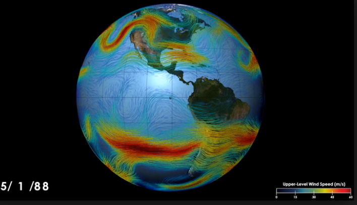
A horizontal temperature gradient exists while moving North-South along a meridian because the curvature of the Earth allows for more solar heating at the equator than at the poles. This creates a westerly geostrophic wind pattern to form in the mid-latitudes. Because thermal wind causes an increase in wind velocity with height, the westerly pattern increases in intensity up until the tropopause, creating a strong wind current known as the jet stream. The Northern and Southern Hemispheres exhibit similar jet stream patterns in the mid-latitudes.
Using the same Thermal Wind argument, the strongest part of the jet stream should be in proximity where temperature gradients are the largest. Due to the setup of the continents in the Northern Hemisphere, largest temperature contrasts are observed on the east coast of North America (boundary between Canadian cold air mass and the Gulf Stream/warmer Atlantic) and Eurasia (boundary between the boreal winter monsoon/Siberian cold air mass and the warm Pacific). Indeed, the strongest part of the boreal winter Northern Hemisphere jet is observed over east coast of North America and Eurasia as well.
A similar argument can be applied to the Southern Hemisphere. The lack of continents in the Southern Hemisphere should lead to a more constant jet with longitude (i.e. a more zonally symmetric jet), and that is indeed the case in observations.
|