Ideally, this is best down using two locations at the same meridian (line of longtitude on the earth).
As latitude is equivalent to declination, then using the difference in shadow lengths at noon will define the angular difference between two locations on the earth.
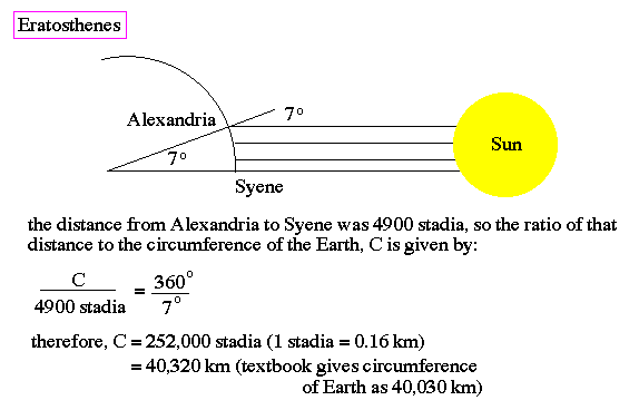
Historically this was done by Eratosthenes using a known location where the sun was directly overhead and cast no shadow and another location where the shadow at that same time was approximately 7 degrees. Thus the angular distance between these two locations (Syene and Alexandria) was about 7 degrees. If you then walked from Syene to Alexandria (or took a camel, or whatver) with a tape measure to measure the distance, then you could calculate the radius of the earth using ratios as detailed below.
We can repeat this exercise conceptually, by simply using a GPS unit or equivalently google maps
Step 1: Find two locations on the same longitudinal line placed at some known distance apart - the bigger the distance the better.
Step 2: Measure the shadows at noon in both places on the same day. The size of the shadows will not be the same for the two locations. Or more accurately, the Sun's position is slighly different. As the diagrams show, the Sun is directly overhead (at Zenith) at Syene, but approximately 7 degrees from zenith at Alexandria.

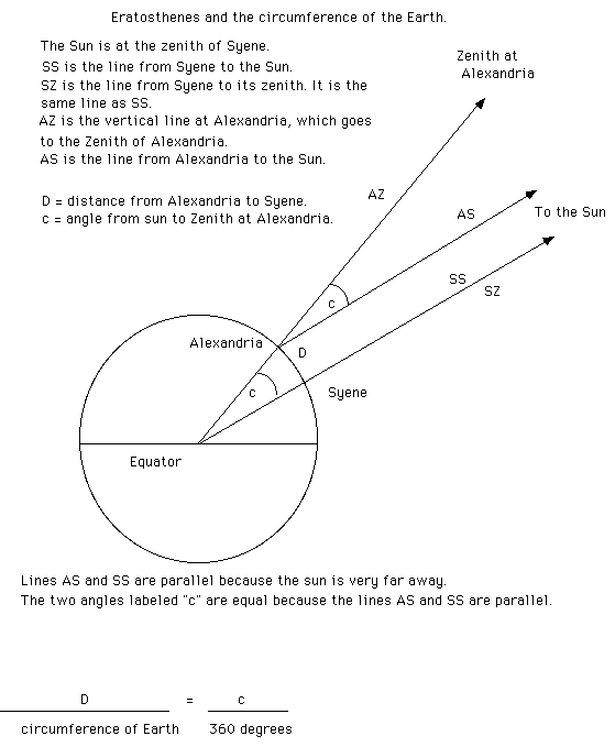
Step 3: The difference in the size of the shadows for both locations is related to the Earths curvature. Based on the fact that the Earth is a sphere (which the Greeks DID believe) and determining the curvature from the difference in shadow lengths, the circumference of the Earth is determined.